

Day Three Lake Mackenzie Hut to The Divide
All was quiet and still in the valley as I paid a visit to the outside toilet during the early hours. I could see the stars were out so turned off my head torch. As my eyes adjusted to the dark I became aware that above me, the Milky Way was stretching out gloriously across the inky black Southern night sky. A million diamonds twinkling through a black curtain. I stood there for a while, mesmerised by the sight until the night air started to chill me and I made my way reluctantly back into the hut and my warm sleeping bag. The clarity of the air in New Zealand and the lack of light pollution in the mountains has meant regular sightings of the Milky Way during our tramping adventures and it has been a joy to see the stars of the Southern Hemisphere throughout this trip, even if I have not quite got used to seeing Orion upside down.
*Click on any image to open in new window*

What day two of the Routeburn Track lacked in forest walking is more than made up for on day three where the walking is mainly through forests of beech and Ribbonwood trees. It was sad saying goodbye to Mackenzie hut, not just because it is in the most beautiful location imaginable but also because it will be our last stop in a ‘Great Walks’ hut. We have some day walks planned for the rest of our Time in NZ but no more multi day treks.

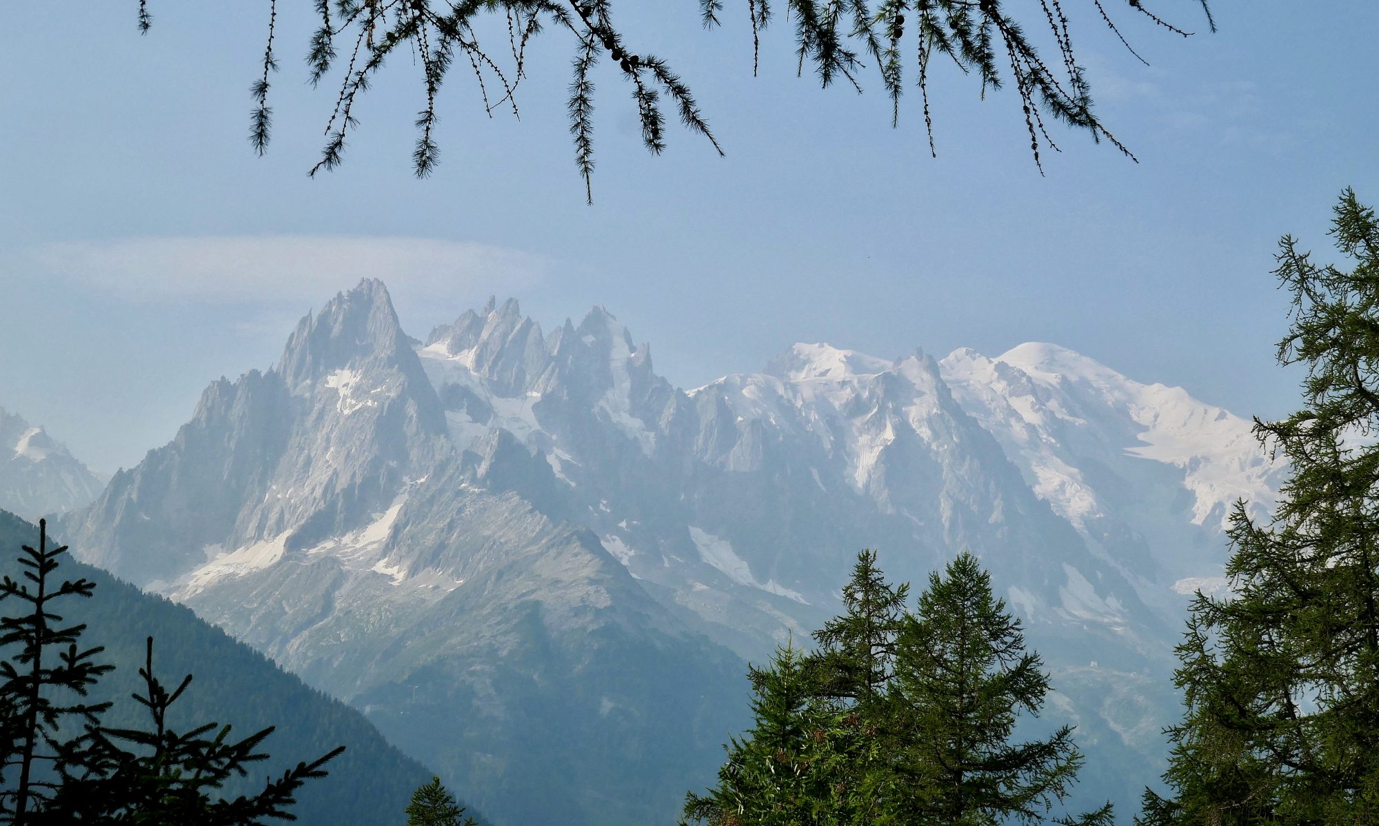
And so it was a melancholic start to the day as we headed out into the forest. The trail heads gently up through the beech trees until settling around the 1000m contour, following the eastern side of Hollyford valley and providing tantalising glimpses of the valley itself and the Darran mountains beyond through gaps in the trees. The bulk of the Ailsa mountains blocks the view eastwards.

Gwen and I settled into our rhythm and enjoyed the gentle walking, the gradient taking us slowly upwards through the trees to the background noise of birds and water. There are a number of fast flowing streams pouring down from the heights above and crossing the path and several metal footbridges have been placed over the larger ones.
After a while, a grassy flat called the Orchard is reached. Here the trees are the Ribbonwood tree and because the forest isn’t as dense the views open up across the valley. Once again we have been blessed with a dry and sunny day. There is just enough breeze to cool us and the walking conditions are perfect.


From the Orchard we can see Earland falls in the distance. As we get closer the roar of the falls gets louder until finally we can see it through the trees and a short while later we are standing underneath the waterfall.


The power of the falls, its thundering water plummeting 174 metres off the mountain and tumbling down the cliff face in a long white plume is evident by the wind swirling around us and the noise as tons of water hits the rocks and rock pools at the bottom.
Having seen Sutherland falls, the highest and arguably the most spectacular in New Zealand I had wondered whether I would be disappointed by Earland falls. Standing underneath it though, spray on my face, wind in my hair and noise all around me I’m impressed enough. I also manage to keep my camera lens dry long enough to get some video which I couldn’t manage at Sutherland Falls. The trail skirts underneath the falls getting pretty close to them, crosses a footbridge and turns back onto the forest path which is then followed down to Lake Howden.


Once again we find ourselves in ‘Fern Gully’, walking along the trail with waterfalls, mosses, ferns and foliage of all different shades of green all around us.

Lake Howden was the perfect place to stop for some late lunch and there was a picnic table right by the lake which had our name on. After the efforts of the morning and the noise and excitement of Earland falls it was good to just take some time to ‘be still’ and take in the peace, quiet and glorious scenery that surrounded us.


The only sound was the sound of the birds singing softly in the forest and the calm of the lake and surrounding mountains, all carpeted in green provided the perfect atmosphere for us to spend some time reflecting on our journey which sadly was nearing its end.
N.B. Subsequent to our visit, Lake Howden hut was hit by an avalanche and sadly it was decided not to rebuild it.

Suitably refreshed in body and soul we reluctantly set off on the final leg of our three day journey along the Routeburn Track. leaving Lake Howden, the trail heads uphill for about eight hundred feet, the biggest climb of the day, until a Col is reached. At the Col, the Key Summit path branches off the main trail and you have a choice whether to visit the viewpoint or carry on down to the finish at the Divide. As we are not likely to pass this way again, the choice was easy for us. We dropped our rucksacks at the junction, confident that they would still be there on our return and headed off up the path to Key Summit.

The path climbs upwards on a couple of zig zags for another 300 ft or so but then levels off as a wide expanse of flat grassy moorland is reached. There is a marked nature trail around the summit plateau with information boards and a metal indicator plaque naming all the surrounding mountains.
The view is quite spectacular, in every direction there were uninterrupted views of the mountain ranges of the Southern Alps of New Zealand that we had become familiar with over the last few days. The Humboldt, Darran and Ailsa mountains were all on display. To the north I could see the Harris Saddle that we had crossed over yesterday. Lake Marian and the Hanging valley, which are often in shadow apparently could be clearly seen and the peaks were all free of cloud. It was a fitting end and the perfect climax to our journey along the track.


As we walked our way around the nature trail I could feel and see the weather starting to turn. The sun was starting to disappear behind ominous looking grey clouds and I wondered whether our run of dry walking was about to end at the final hurdle. Back at the Col we collected our rucksacks and started the journey down the trail to the finish at the Divide. On the way we passed a lot of people, a coach party I think who were on their way up. I couldn’t help but notice that all were in shorts and t shirts with not a raincoat between them.

As we got closer to the finish, the sound of cars on the Milford Rd could be heard and before we knew it we were out of the forest and stood in the car park by the DOC signpost that the marked the end of the track. Gwen and I congratulated each other and took some pictures but there was little time to contemplate our achievement any further as within a minute, the rain that had been threatening since Key Summit arrived.

When I say arrived, I mean ‘biblical flood’ arrived. Great sheets of water poured down from the sky, a huge deluge that soaked everything instantly. We rushed into the shelter across the car park to escape it and I couldn’t help thinking of all the poor people we had passed on the way up who would now be soaked to the skin. Looking out from the shelter at the severity of the rain I was also thankful, that in our seven days walking in Fiordland National Park, one of the wettest places on Earth, we had managed to avoid all but an hour or two of rain on the first day of the Milford Track.
We waited in the shelter for a while but when it was clear that the rain wasn’t going to stop ant time soon we made a mad dash to the car park, found the hire car, recovered the lock box with the key inside, and scrambled into the car as quick as we could.
With the rain hammering on the windscreen and steam coming off our warm, wet clothing I couldn’t help but laugh at the sudden and incongruous end to our walk. But inside I was also smiling, and very, very satisfied.
To Find All My Walks In New Zealand Click Here
Route Map, Walk Stats and 3D Flyover of Route Below
Amazing looking hike and great shots of the waterfalls!
Thanks Mike, it was a great hike and I do miss NZ, it’s a fantastic country with some amazing scenery
Great read, loved the photos and videos
Thanks, glad you enjoyed it