

MacGillycuddy’s Reeks may sound like a character out of a Roald Dahl book but is in fact an extensive mountain range in County Kerry, Ireland and the home to Ireland’s highest peaks including its highest, Carrauntoohil. The far south west of Ireland is a little out of the way for an Englishman but a road trip around the ‘Emerald Isle’ with some friends provides an opportunity, should the timetable and the changeable Kerry weather oblige to climb this mountain.
Our friends Rob and Wendy, who are not hill walkers have said they would join me on the walk for payment of Guinness. Mrs E is not so easily bribed and decides a day reading in the garden is preferable to a day sweating it up a hill, especially the biggest hill in town. With the forecast saying we are good to go we pack rucksacks and head off early from our Airbnb. On route we pass Lough Acoose and are treated to a fine view of the Reeks rising above the morning mist across the water.

Cronin’s Yard is the usual starting point for an ascent of Ireland’s highest mountain and it serves as a one stop shop with parking, food, camping and accommodation all available. On arrival it’s clear that the good weather has brought out the crowds, the main car park is already full and the overflow field is not far off.

There are a couple of routes up Carrauntoohil from Cronin’s Yard but not being overly familiar with the mountain and with Rob and Wendy not used to hillwalking the Devils Ladder route stands out as being the least complicated.

The path up Hags Glen is a good one and the gradual incline is hardly noticeable. Before long the Gaddagh River is crossed and then the valley sides start to narrow. The sun has come out and burnt off the morning cloud from the tops although wispy banks still drift ethereally around in the valley.

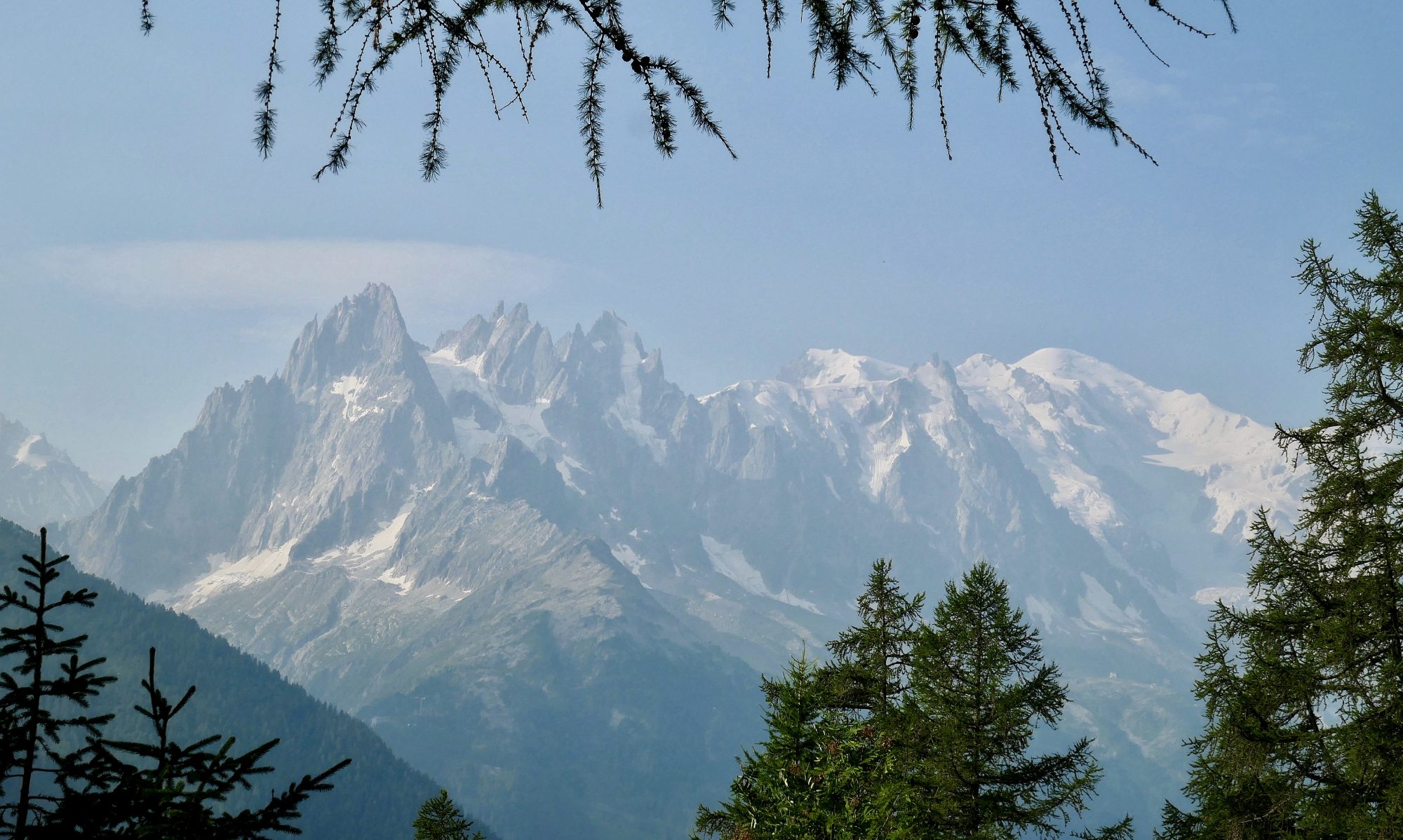
Arriving at Lough Callee the pyramidal shape of Carrauntoohil looks very impressive and I’m struck by just how bright green the sheer cliff faces of Carrauntoohil and the surrounding hills are. South West Ireland is the first land The Gulf Stream meets on its way up from the Gulf of Mexico which means the climate is warmer than average and plant life gets to grow all year. It’s easy to see why it’s called the Emerald Isle. Lough Callee is not dead calm but calm enough to get a nice green reflection from Cnoc an Chuillinn, rising up steeply behind it.


From the Lough everybody is heading to the same place, the head of the valley and the clearly visible, man made scar of a path that is the Devil’s Ladder.

There follows maybe an hour and a half of sweat and toil struggling up a very steep path that is so worn and loose that sometimes it’s one step forward and two back. Care has to be taken to avoid sending rocks down onto those coming up behind. Eventually and with some relief the top of the gully is reached and we step out onto the col between Carrauntoohil and Cnoc na Toinne and take a breather.

Having endured climbing up it, the view back down the ravine to Lough’s Callee and Gouragh and the flatlands of Killarney beyond can now be enjoyed. Ireland does have National Parks but it came as a surprise to me to find out Carrauntoohil and Macgillycuddy’s Reeks are privately owned. The internet tells me there have been issues regarding the upkeep of the paths and the Irish Times was wondering back in 2019 whether it was time to make the Reeks a National Park. I know I haven’t walked up a route as badly eroded as Devil’s ladder in a long time, if ever.

Having reached the col the struggle of the ladder is forgotten and enjoyable walking returns. After admiring the view south, not seen up to this point it’s time to tackle the last section of climbing up the south flank of the mountain to the summit. It’s still steep but the path is kinder and there are ever expanding views along the length of MacGillycuddy’s Reeks down to Lough Leane and Killarney to take in.


Eventually we arrive at the summit plateau and join in with dozen’s of others who are enjoying the sunshine and views on what is pretty much the perfect day to climb up to 1,038 metres. The summit is marked by a large metal cross embedded into the ground next to a stone shelter. The mountain drops off steeply on three sides which gives it an airy, exposed feel. Across a vast deep hollow is Beenkeragh, Ireland’s second highest mountain. Connecting it to Carrauntoohil is the Beenkeragh Ridge, a narrow arete that is not for the faint hearted. The clear views over the rest of McGillycuddy’s Reeks and into Kerry beyond are quite spectacular.


I wasn’t relishing the idea of slip sliding my way down the rubble of Devil’s Ladder on way back and whilst eating and enjoying the views I noticed what looked like a good zig zag path going down the mountain on the other side of the valley. After a look at the map I picked out a guy with an Irish accent who looked the most likely to be a seasoned hillwalker and he confirmed that was the best way down, avoiding Devil’s Ladder altogether. It did involve some additional ascent but overall was a far better descent route.


Rob and Wendy were happy so after enjoying the party atmosphere on the summit we retraced our steps back to the col, passed it by and continued on up to the top of Cnoc na Toinne. Any path would have been better than the rubble chute but the Bóthar na Gíge zig zag route as I now know it to be called was a good one with great views back to the summit of Carrauntoohil, now way above our heads which we wouldn’t have got going down the ravine.


From Cnoc na Toinne the path curves around the head of a small valley before turning into the steep zig zags that lead to a rapid, knee juddering descent off the hill. Towards the end it becomes a little lost among the rock bluffs but eventually we join back up with the main path just before the two Loughs and from there it’s a simple walk in the afternoon sunshine back to the start.

Later on, in O’Shea’s bar we celebrate our achievement over a good meal and several pints of the black stuff. There are some aching legs and I’m not sure I’ve turned Rob and Wendy into hill walkers. But aching legs will stop aching and what then remains is the eternal satisfaction of having stood on top of the whole island of Ireland. And who else can say that?
To See More European Walks And Trails Click Here
Route Map, Walk Stats, Geolocated Picture Gallery and 3D Flyover Video Below.
Click ‘Learn more’ on the map. Note: you won’t see the map if reading in WordPress reader but click on the little world at the top of the page to view it on the browser.
What a fabulous day for a climb, Jim! So glad you found an alternative route down. It’s a long way on your bum!
Thanks Jo! Yes that wouldn’t have been pleasant! 😀
🤣🩵
Looks terrific.
Thanks John, yes the range is really impressive, I think if it was in the Lakes or Scotland we would read a lot more about it
Indeed.
I know nothing at all about this part of the world – maybe I should change that!
I really enjoyed this blog Jim, even if I am being a bit partisan about it being my home country lol.
Thanks Aud, It’s a lovely country and I really enjoyed the far South West, it reminded me of the far north of Scotland
Wow that’s a good spot, if a little busy (although you can see why!) Must add to my endless list!
😂I have lots of sub lists, that way no one list looks too long! This was on the ‘highest points of the country’s of the British Isles’ list 😀
This is such a wonderful post about a mountain I have yet to climb. I am glad to see you had a wonderful day and weather for reaching the top of the highest mountain in Ireland. Thanks for sharing, and have a wonderful day 🙂 Aiva xx
Thank you Aiva, it was the perfect weather for it. Living in Sligo it’s not too far from you and you could climb it out of the tourist season when it’s a bit quieter! 😀
It’s been on my list for a while, but every time we arrived in Kerry, the weather turned for the worse and we had to cancel it. But I am not giving up! Cheers xx
No, never give up!
Amazing views from the top, well-worth the effort!!
Thank you Christie, yes views like that are certainly worth the effort, although it might not seen so at the time!
Absolutely stunning views, Jim. I would’ve put my hands up to join you all. As always your descriptive posts would encourage most non walkers to challenge themselves.
Thank you Suzanne, the views were good and the weather played its part that day in a notoriously fickle part of Ireland. A good walk is never forgotten 😀
Like NZ we are all living on a reasonably narrow island so various degrees of torrential rain and gales are going to occur on a regular basis. We’re tough 😉
Looks a beautiful walk and some great views. Love those pyramid shaped hills.
Thanks Shazza 😄
This is a gorgeous walk. Thanks for sharing your beautiful photos 😍.
Thank you Mélodie, it’s my pleasure 😀
Gorgeous! What a wonderful, if lung-busting, walk! Thanks for sharing, Mel
Unfortunately the weather was too poor to attempt the peak on my visit to Ireland but I’m glad you had a good day for it!
Thanks Amie, yes we were fortunate as it does rain a lot on the west coast!