

It’s a promising morning, the sun is shining and blue sky is all around. As I set off from Sykeside campsite I notice a band of cloud lingering over the higher fells. I figure however that the sun will have long burned this off by the time I get up there. My intention today is to walk up Gray Crag, Thornthwaite Crag, Stony Cove Pike and finish on Hartsop Dodd.

To get to Hartsop I follow the permissive path that runs alongside the road and means you don’t have to risk your life on the pathless A592. I have walked on the other side of this small lake many times but this is a first and the path is far prettier than I imagined.

At its far end it drops onto the lake shore where there is a splendid view across the water to Dovedale, my eyes being drawn upwards to the imposing rock of Dove Crags, ethereally drifting in and out of view in the cloud.

Dorothy Wordsworth walked here on the 16th April 1802 (a good reminder of why we should all keep a journal to look back on) and commented far more prosaically than I,
“the boughs of the bare old trees, the simplicity of the mountains, and the exquisite beauty of the path…the gentle flowing of the stream, the glittering, lively lake, green fields without a living creature to be seen on them”.

Having crossed the road the path continues to Hartsop, crossing over Hayeswater Gill and into the small village itself. Hartsop is an ancient settlement and with no pub, gift shop or other usual tourist trappings retains an authentic feel to it, although I am sure, as in most of Lakeland it has its fair share of second homes and holiday lets. Where the road ends there is a car park and once through that I am on the open fell.

I am heartened to see that the first objective, Gray Crag is standing out clear and proud in clear blue morning sky and set off up the track that leads all the way to Hayeswater reservoir. It’s a steady climb and before long I reach the point where I will leave the track and head up the hillside.

The hill is steep and I switch into low gear to grind it out, reminding myself as I puff and blow that the advantage of a steep ascent is at least you gain height quickly. And true enough as I leave the confines of the valley some lovely views open across Kirkstone to the Eastern Fells, my companions of the last two years. Catstyecam and Helvellyn are clear, the Helvellyn edges still retaining a little snow but as I look further south that band of cloud encroaches over the tops again.

Walking up the north face of the mountain, in the Northern Hemisphere at least, means walking in its shadow. All this changes around the 450 metre contour when, like a conversion experience I literally step out of the darkness and into the light. Everything always seems better in the sunshine and it’s good to have the the sun on my face, even if I have to zip down through the layers.

The path continues upwards but thankfully the gradient eases as a false summit is reached and then it’s a steady walk on to the summit itself. From the ridge there is a good view down to Hayeswater and across to the Knott and the whaleback ridge of High Street.

Before long I am stood on top of Gray Crag. Its a neat and tidy little summit with a suitably neat and tidy cairn, a Goldilocks cairn in fact, not too big, nor too small but just right. I have the top to myself and the clarity of the winter air means crisp views all around with the cloudless blue sky and sunshine adding to the joy and satisfaction that comes from standing on top of a mountain, breathing the fresh air and enjoying the views for miles around.

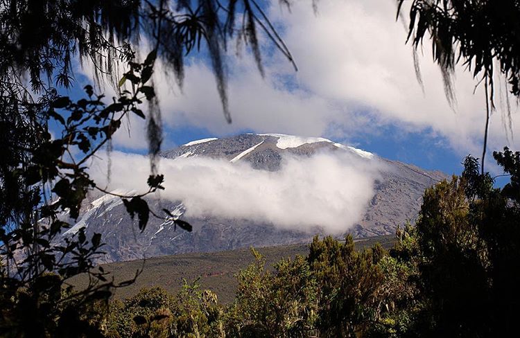
The only fly in this perfect weather ointment is the bank of cloud that has been hanging around all day around the 700-800 metre mark. It hasn’t burnt off and it is hovering suspiciously near the summit of my next hill, Thornthwaite Crag. It is however a mesmerising and unusual site. Perhaps a hundred metres deep it has provided a white cap to the summits around Kirkstone all day. The cloud covers Threshthwaite Mouth but is pouring down into Threshthwaite Cove like a slow motion waterfall, dissolving into nothing in the warmer air of the valley.
Unfortunately for me Thornthwaite Crag is 784 metres high so there is nothing to do but keep walking and hope the cloud lifts off the summit, or better still drops below it by the time I get there.

It’s a fairly straightforward, uneventful walk along the ridge to Thornthwaite Crag. At 700 metres I enter the cloud and when I reach the top I am still in it. The summit is marked by an impressive nine foot column that, on a clear day can be seen all around.

Today however is not that day. Perhaps thirty metres above me, teasing me with its presence is the clear blue sky. It’s so close that if only I could stand on tip toes, stretch out my hand as far as I could, surely I would be able to reach it and pull it down to clear away this leaden murk. But it is no use. The cloud it turns out is also Goldilocks, not too high and not too low, but just the right height to deny anybody standing on Thornthwaite Crag a view of any significance. I hang around for a bit and do my best King Canute, ordering the cloud to move but time, tide and also clouds it appears are not controlled by the whims of mere humans.
Those who have read the introduction to my journey through the Wainwrights (if you haven’t its Here) will know that I have written up my own contract with these hills, one of the clauses being that I will get a view off each summit. I am now obligated to return to Thornthwaite Crag at some point, which is no bad thing.

A guy turns up with his border collie Tommy, (the border collie not the man). They’ve come from Stony Cove Pike where he reports (the man not the border collie) that the cloud is equally as settled over its summit. Walking down to the col at Threshthwaite Mouth gives me time to consider my options. The path down is tough going, extremely worn and steep with loose, wet rocks inviting a dangerous slip and care and concentration is required. Wainwright himself says it is stony and loose and he wrote that in the 1950’s.

At Threshthwaite Mouth I have considered my options and will take what was my escape route down into Threshthwaite Cove and back to Hartsop via the valley leaving Stony Cove Pike and Hartsop Dodd to another, brighter day. Changing plans when circumstances change is part of good mountain safety and route planning and although it always feels slightly disappointing I have made enough mistakes in the past ignoring this rule (in life as well as hillwalking) to know it is the right thing to do.

And so I set off into Threshthwaite Cove. It’s a steep drop off at first but as I walk out of the mist, the gradient eases, the views return and the sun starts to shine again. At the bottom of the Cove the valley widens into Pasture Bottom and the path continues along the valley side with a dancing Pasture Beck keeping me company.

Ahead of me, Brock Crags my walk tomorrow is seen to good effect. Further down the valley a Kestrel hovers, its head perfectly still, eyes fixed on some unfortunate creature on the ground. It repeats this over and over but I never see it dive for a meal.

Past Hartsop I drop back onto the shore path at Brothers Water. All is quiet and still at the lake. The sun now sits above High Hartsop Dodd, it’s rays bursting out like lasers from behind the clouds and creating on the lake a white road of light that shimmers and reflects on the rippling surface.
*************************
Back at the campsite, the clouds are still hovering over the summits. They have ruled the day, a humble reminder that we will always be the subjects, never the rulers on this planet, nature always wins. It is not until sundown that I see them finally relinquish their hold on the high tops.
To Find All My Walks In The Far Eastern Fells Click Here
Route Map, Walk Stats, Geolocated Picture Gallery and 3D Flyover Video Below.
Click ‘Learn more’ on the map. Note: you won’t see the map if reading in WordPress reader but click on the little world at the top of the page to view it on the browser.
I love that rollercoaster of clouds, Jim, though I’m sorry it messed your plans up. Superb scenery and videos. I so enjoy exploring with you.
Thank you Jo for your encouragement, I’m glad you enjoy my posts. the cloud was certainly unusual, just a shame it wasn’t a bit higher or lower! Still the mountains aren’t going anywhere and I’ll look forward to returning to that hill. 😀
😁💗
Fabulous. I love your photos, and the cloud inversion is glorious. Can’t wait to have a go at these next time. Also, I’m relieved to see I’m not the only one to puff and blow my way up, because sometimes I do wonder!
Thank you Ruth, the cloud was spectacular just wish it had been a bit higher or lower! Re walking style I’m certainly more steam engine than bullet train! And I think there are plenty who puff and blow but just pretend to be Olympic athletes when others are near 😄
Ha I’m sure you are right
We were there last weekend. Managed all four Wainwright’s, but it was cloudy and windy.
That’s good, I’ll be heading back up soon to catch Thornthwaite Crag when it’s clear 😀
A gorgeous walk, even with the cloud! Thanks for the heart-starter stroll. Mel
Thanks Mel, yes, I have grumbled about the cloud but it was impressive 😀
Beautiful views including the clouds rolling off the hills. Too bad your view at the top was obscured but that’s life in the mountains. Maggie
Very true Maggie, even when you plan a clear day the weather sometimes has other ideas!
I do want to take the dog to Heyeswater as he has a map of the lake District where he has swam or paddled. Heyeswater is one lake he ( or we ) haven’t been to yet.
It’s very accessible, a fairly easy walk from Hartsop on a track.
Thank you, I have a list of so many things to visit in Cumbria, it’s on there. 😊
Beautiful views .Those mountains caught my attention Thanks Anita
Thank you Anita, yes it was a lovely day and the weather showed off the mountains beautifully