

From the car park at Hartsop the lush green tree peppered slopes of Brock Crags, my objective for the day rise up blocking any view to the north east. The view up the valley compensates with Gray Crag and Hartsop Dodd, their tops clear of cloud today, looking down from their lofty heights, silent observers of daily life in this small attractive lakeland village. The parking is free but donations are encouraged to support the local primary school. I went to school in a city and as I get my boots on I wonder what it must be like to go to a small rural school, surrounded by sheep and mountains in one of the most beautiful National Parks in the country.

It’s another bright, dry day and for a short while I walk the same track as yesterday when heading to Gray Crag. The path splits at Hayeswater Gill and I fork off left heading up a track that leads all the way to the old filter house.


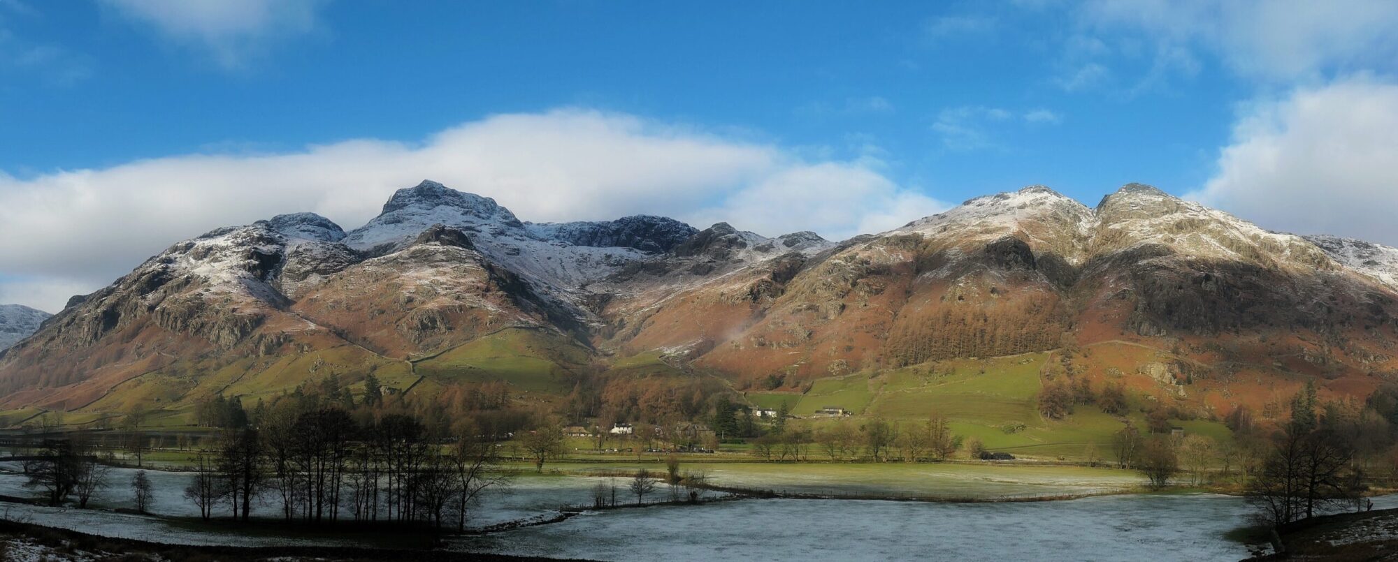
Along the path there is a good view up the long valley of Threshthwaite Glen, leading to Threshthwaite Cove. Threshthwaite mouth is clearly seen, free of the impressive slow motion waterfall of cloud that was pouring over its lip yesterday.

Although retaining the name, the filter house lost its original function when Hayeswater ceased supplying drinking water to Penrith in 2004 and the building is now a rather remote private home. Hayeswater itself, it’s dam dismantled has reverted to being what it was originally, a rather lovely little mountain lake.

Just before the filter house is reached a path heading up the fellside at an angle is joined. This path also has some history, originally being the route of the pipeline running from Hayeswater to Penrith. From Wainwright’s chapter on Brock Crags, written in the mid 1950’s it is evident that it had only just been put in and unsurprisingly he is quite disparaging, describing it as an ‘ugly scar along it’s fair breast’. He does also say ‘nature is a great healer’ and I can testify that in 2023 there are no clues remaining of the disruption he describes and I would have no idea that I was walking with a pipe buried deep beneath my feet.

There is a guy ahead of me and in true hillwalker/sheep behaviour I decide he must be going my way and just follow on behind him. This is despite having an actual map with an actual satellite (actually four) placing a precise blue dot on the actual very spot where I am standing on this fair planet. Consequently, when he stops two hundred metres ahead of me and consults his map, I stop and consult my map and we both realise we have overshot the turn off. It appears that having the ability in the 21st century to know exactly where you are is no help at all if you can’t be bothered to take your phone out of your pocket. Sheep and Lemmings, all of us.

The path up from the pipeline track is an absolute delight. Grass and soft earth, set at a perfect angle for gaining height at a steady rhythm without needing to stop. If only more paths were like this gem. After a sustained period of uphill in a straight line, the path levels, curves it’s way around heathery mounds and eventually I arrive at a gap in a wall where the summit path heads off at a right angle. There is an impressive view here of Hayeswater, set deep in its glacial bowl, surrounded on three sides by the steep slopes of High Street, Thornthwaite Crag and Gray Crag.

The path to the summit generally follows the line of the wall through a series of heathery hillocks and occasionally boggy ground. I crest a rise and see the summit on the other side of a boggy pool. I decide to go to the right of the pool (having gone the other way on the way back there isn’t much difference). I pass a couple who are just leaving and we say hello, the man proffering the sage advice ‘it’s a bit blowy’.


And true to his word when I arrive at the summit I am greeted by a cold, blustery wind funnelling down the valley and blowing a hooley over the top. I had been protected from this on the east of the mountain and in the hollow by the wall but was now exposed on the summit. Just after my arrival a young woman arrives with a couple of dogs. She is moving at pace. Within a minute she has taken a picture and gone, not a word said between us.

I find a place to sit down as out of the wind as is possible and have some hot chocolate and an eccles cake, which I had been particularly looking forward to as I had forgot to pack them yesterday.
The reason why people walk on mountains is, I suppose, as varied and individual as people themselves and the mountains welcome all without any judgement. I’m not one for rushing up a mountain however, or rushing away from its summit once I have got there. For me hillwalking is a contemplative exercise. It gives me time to think, be present in the moment and reset. To take time out from the other demands on my time and life. The mountains provide constancy in a world of change. They are always bigger than my own personal circumstances and I need reminding of that regularly.

For a smallish hill, the views from Brock Crags are remarkably good. Bordering the Kirkstone valley means that the views west are unobstructed and although the weather has turned slightly with the strong wind and ominous dark clouds drifting over, the summits are still clear and there is a visual feast to be had looking at the Eastern and Far Eastern fells. Brothers Water, Ullswater, Angle Tarn and Hayeswater also add their watery contributions to the meal.

Having nourished myself physically and mentally I get out of the wind and drop back down to the more sheltered eastern side. The walk back reverses the walk up and as I approach Hartsop my eye is drawn to rows upon rows of dry stone walls crossing the hillside.

Wainwright dedicated the book I am currently walking through, The Far Eastern Fells to:
“The memory of THE MEN WHO BUILT THE STONE WALLS, which have endured the storms of centuries and remain to this day as monuments to enterprise, perseverance and hard work”.
It’s been a thoughtful walk and I finish thinking about Wainwright’s dedication and those tough Lakeland men of old who built the dry stone walls that still stand to this day and are so much a part of this beautiful landscape.
To Find All My Walks In The Far Eastern Fells Click Here
Route Map, Walk Stats, Geolocated Picture Gallery and 3D Flyover Video Below.
Click ‘Learn more’ on the map. Note: you won’t see the map if reading in WordPress reader but click on the little world at the top of the page to view it on the browser.
Oh those views! I never understand why people don’t want to stop and take it in, wind notwithstanding.
Thanks Ruth, yes some great views from those hills around Hartsop. I think the wind and rain arrived a day or so later.
Beautiful pictures of the gorgeous scenery. I’ve never hiked in the UK, it looks beautiful. Maggie
Thanks Maggie, yes the Lake District, Highland Scotland and Snowdonia are beautiful mountain areas. The weather can be unsettled in the UK with the Gulf Stream but I only walk if I can get view these days so maybe your seeing it at its best!
Mission accomplished, Jim, and plenty of time for thought in beautiful surroundings.
Thank you Jo, yes plenty of time to think whilst walking, and enjoy the outdoors.
These views are so photogenic. Thanks Anita
Thank you Anita 😀