

Day Two Routeburn Falls Hut to Lake Mackenzie Hut
Day two on the Routeburn Track dawns bright and clear. All twenty or so bunks in our room were full but there were no ‘nighttime noises’ and I slept well, helped no doubt by the fact that the girls from Otago were at the opposite end of the lodge. The weather forecast is for rain early afternoon so I am keen to get moving as soon as we can. After breakfast we finish our packing on the balcony of the hut enjoying the morning sunshine and final views down the main Routeburn valley.
*Click on any image to open in new window*

Packing all done, we set off up the trail passing by Routeburn Falls. Beyond the falls the trail heads uphill at a steepish incline for a short while until the confines of the valley containing the Routeburn Left Branch river is reached. All is quiet in the valley, there is no wind and a stillness in the morning air. Only the rushing waters of the river can be heard.


The valley floor itself is fairly wide but the sides rise up steeply towards the respective peaks of Mount Xenicus and Ocean Peak which flank the valley and give it a slightly enclosed feel. The path meanders steadily along the valley floor generally following the line of river which is on our right. Although I can’t see it yet, the stark demarcation line between light and dark on the valley side tells me that the sun is getting higher and finally it breaks over the top of Ocean Peak bathing us in Its light and warmth.

The sun lights up the valley and warms our bodies so we take the opportunity to have a break and take some pictures.

I can see that the moon is visible, high above mount Xenicus, like a feint white button against the backdrop of the bright blue morning sky. It’s 8.30am, the start of a bright New Zealand mid summers day. That means it’s 7.30pm (yesterday) back home in the U.K. looking at the moon I allow myself a moment of romanticism, imagining that my wife is looking up at that same moon, at this very same time on a cold, dark mid winters evening on the other side of the world.

As we admire the view a group of four, Italians I think pass by. These are the only people we have seen in the valley and as we resume our walking we have the valley, the views, the sun, the river and mountains all to ourselves. It’s as if they were there for our enjoyment only and I take some time just to be present in the moment, thankful for the privilege of being able to walk through this magnificent scenery.


In the middle of the valley there is a bit of board walking along decking, the ground is dry but I imagine because the valley floor is flat it would be boggy in the rain. As the head wall of the valley is reached the gradient increases as the trail heads upwards towards Lake Harris and the Col at Harris Saddle.


As we gain height Lake Harris comes into into view. Nestled in a bowl below the Harris saddle, it’s waters are a dark sapphire blue. It looks inviting, but not so inviting that I want to lose the height we have gained to visit its shore.

Before the saddle is reached there is a bit of rough walking as the head wall of the valley is traversed. The trail heads up along the steepening valley side and the path is narrow and rocky in places. This doesn’t last long and after a short while the gradient eases, the path opens up and ahead and slightly below us is Harris Shelter at the top of the Harris Saddle.

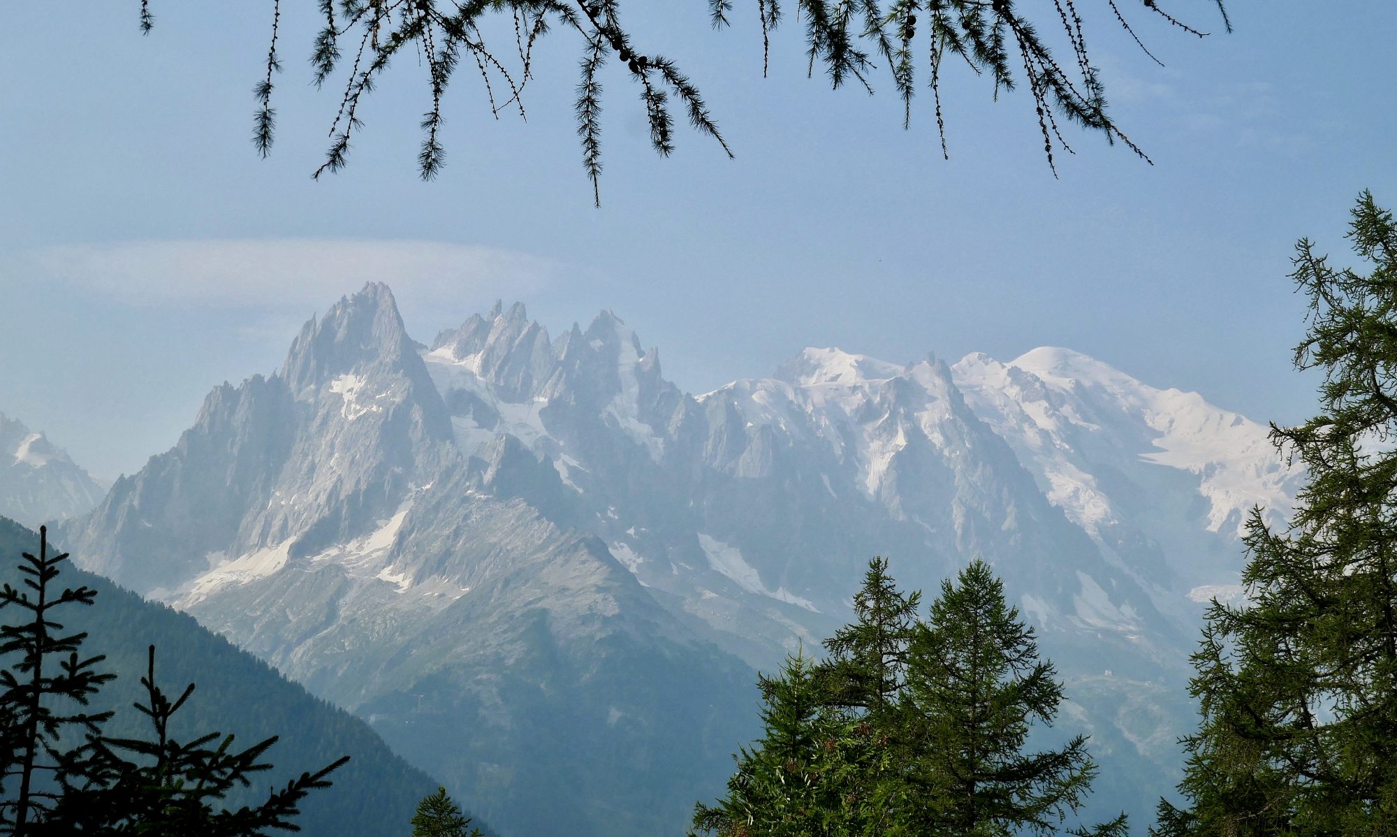
The view here is glorious. Lake Harris, its elongated shape now clear is far below your feet and there is an uninterrupted view all the way down the valley. The Routeburn River Left Branch winds like a silver snake along the valley floor leading your eyes towards the peaks of the Southern Alps on the horizon.


The shelter is a simple affair. A pyramid shaped small shelter with one wooden room and benches along the sides. Outside there is a veranda and an toilet at the back. Unlike the shelter on top of Mackinnon pass there are no gas burners or posh bit for guided hikers to go. At 1277 metres (4,189ft) it’s also higher than the Mackinnon shelter and is not only the high point of the day but the highest point on the Routeburn Track. Somebody has left a New Testament and Psalms in the shelter with Psalm 121:1-2 highlighted “I lift up my eyes to the hills. From where does my help come? My help comes from the LORD, who made heaven and earth”. Staring out at the hills it seems very apt.

Gwen and I enjoy lunch ‘alfresco’ on the veranda. Although at 4,000ft it’s not particularly warm, the sun is high in the sky, the views are great and the visibility is crystal clear so it would be a shame not to. We have made the high point of the day, done most of the hard yards of walking and the sun is still out with blue skies above. I am beginning to hope that the forecasted rain may not arrive and we can get to Lake Mackenzie without having to break out the waterproofs. Arriving at the Harris Saddle means that the views West, hitherto blocked by the bulk of Ocean Peak can now be seen. And what a view it is.


Across the deep gulf of the Hollyford valley, the long range of the Darran mountains rise up and dominate the skyline. Several peaks stand out above the others but the whole range has a covering of snow above the 1500 meter mark and this band of white is sandwiched between the blue sky above and the greenery of the lower slopes below leading down to the valley floor and the Hollyford river. The whole scene is constantly changed by cloud shadows moving over the landscape casting great swathes of the mountainside alternately into light and shade.


On leaving the shelter we cross over from Mount Aspiring National park into Fiordland National park. The trail here is a joy. The path consists of a high level traverse along the valley side. Staying roughly around the 1100 metre mark, the trail heads South on a good path, providing expansive views across to the mountains and up and down the Hollyford valley, its river flowing along the valley floor. Looking North I think I can see the Tasman sea beyond Lake McKerrow.


Whilst the trail maintains a high level along the valley side it is not flat and there is a fair bit of of up and down as the path follows the contours of the mountainside. As we make progress along the trail we start to meet trampers coming the other way and every five minutes there is an exchange of pleasantries.
There are a number of bridges in place crossing over the fast flowing streams, some quite substantial, that are pouring down the slopes from Ocean peak. Towards the end of our promenade walk, before the path turns away from the valley and we start to lose height Gwen and I stop for a bite to eat and one last look at the scenery. As we turn the corner I notice that clouds are darkening and starting to lower over the Darran mountains.

At the southern end of the ridge the trail turns abruptly north east, leaving the Hollyford valley behind and rounding a corner into the valley that houses Lake Mackenzie. After a short while, the lake comes into view, a long turquoise lake stretching along the valley floor far below us.


The path down is fairly steep, zig zagging down the mountainside until, about half way down we enter birch forest. This is the first time we have walked amongst trees today and walking through the woods, with its shade and stillness is a pleasant end to the walking day which in the main has been at high altitude and exposed. The sound of birds returns and the robins that we saw so much of on the Milford track are just as curious and cheeky.

A sign in the woods points us to Lake Mackenzie Hut and when we arrive we find that we are one of the first to arrive so have the choice of bunks and time to have a good look around and chill. The hut is in the most beautiful of settings. Nestled on the edge of the forest and surrounded by mountains but only fifty metres from the lake shore with great views up the valley, simply stunning. Over dinner we chat to a fellow Brit who had walked up Conical Hill despite the avalanche warning signs. Fortunately he had lived to tell the tale.

For much of the walk today I felt as if I was dreaming, not quite believing that I was actually walking through this amazing landscape with its blue skies, lush forests, crystal clear streams, deep pristine lakes and snow topped pointy mountains.

After dinner Gwen and I take a walk down to the lake and sit on the rocks by the shore looking out over its still waters to the serene mountain view beyond. As we are sitting there, a rainbow appears over the twin peaks at the head of the valley. The rain never did appear and I take this as a sign to mark the perfect end to the perfect day. As I go to bed I am left wondering whether today was the finest days walking I have ever done.
To Find All My Walks In New Zealand Click Here

Route Map, Walk Stats and 3D Flyover of Route Below