

Day One Routeburn Shelter to Routeburn Falls Hut
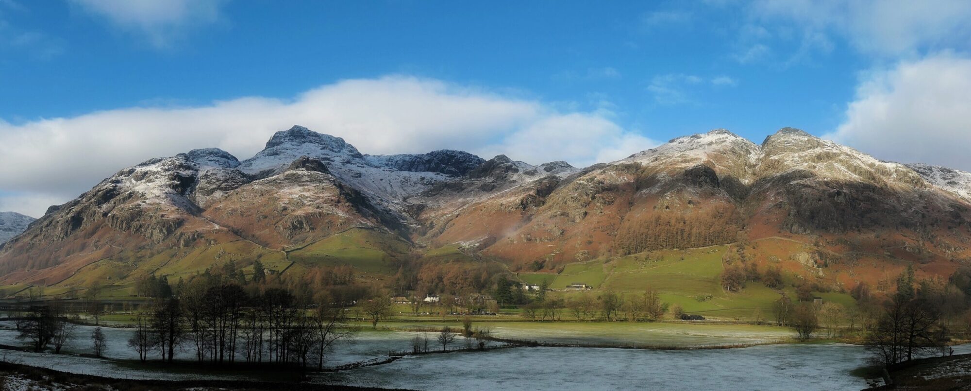
Driving to the start of the Routeburn track I was wondering if the walk we were about to do could possibly compare with the beauty and majesty of the Milford track that we had walked only one short week ago. As we left Queenstown and joined the lake road heading north, I realised I needn’t worry. Lake Wakatipu, looking like a huge sapphire jewel set deep into a ring of mountains appeared before us glistening in the morning sun. It stretched for miles and beyond that, the Southern Alps of New Zealand reached their snowy topped fingers high up into the bright blue cloudless sky. Even the road itself, straight as an arrow in places and lined with purple Lupins seemed to be leading us invitingly into the heart of the mountains. It was the road to El Dorado and for the next three days we were about to partake of its golden treasures.
*Click on any image to open in new window*


The last few kilometres to the shelter were slightly hair raising. Driving down a gravel dirt track with stones flying up everywhere made me wonder if I had enough windscreen insurance on the hire car but thankfully we arrived without incident. Routeburn shelter has the appearance of a bus station, but a bus station in paradise. Surrounded by high mountains and thick beech forest it is a picture of beauty. As its name suggests it provides a good shelter for trampers about to start the trail or for those finishing and waiting for the bus back to Civilisation.

Like the Milford Track this is one of New Zealand’s ten ‘Great Walks’. Unlike the Milford though it can be walked in either direction and the huts can be booked independently giving it the freedom and feel of any other long distance walk. We have decided to walk South from Routeburn Shelter to the finish at the Divide. The trail also passes through not one but two of New Zealand’s National Parks, starting in Mount Aspiring and finishing in Fiordland.

The weather forecast is mixed but we are hoping for the best and as we finish packing our rucksacks with everything we will need for the next three days the sun comes out. Could it possibly be that we will have another dry and sunny ‘Great Walk’. Rucksacks packed and car key locked in the lock box so it can be moved the 340km by road to the Divide to meet us at the end, I have a little look around the shelter before we set off. Information boards tell the history of the track and what flora and fauna can be seen and there is a big covered area with some wide benches to sit on both under cover and out in the sun, which is now positively hot.


As we are about to leave, a fellow tramper walks across the bridge to finish. He drops his pack and lies out prostrate on the bench, sunning himself, satisfied in his achievement. A nod and a smile passes between us, in his end is our beginning.


Right at the start we cross over the Routeburn river, from which the track gets its name on a suspension bridge. The path then heads up through the trees following close to the fast flowing burn, it’s waters crystal clear and the sound of its hurry a constant in our ears. For the first mile or so the track is also a circular nature walk and there are a few day walkers around enjoying that path.

After a second bridge, sugar loaf swing bridge, the nature trail leads back to the shelter taking most of the day walkers with it and a familiar quietness descends onto the trail. The birds, our footsteps and the roar of the Routeburn are the only sounds to disturb the peace and tranquility. The forest is mainly red beech and the trees line the trail like sentinels as we head up the well made path. The sun is now high and its rays are dappling through the moving leaves and branches casting dancing shadows on the ground.


After a short while Bridal Veil bridge is reached. There is a gap in the trees here and the Routeburn river, a turquoise thread in a forest of green can be seen tumbling its way down the valley. After the bridge the walking continues steadily upwards, never steep enough to break sweat though and at a good gradient. We follow the Routeburn, which is intermittently seen through the tree cover but can always be heard, up the valley. Eventually we rejoin the river and cross it for the last time just before Routeburn Flats.


Routeburn Flats is, not surprisingly, flat. It’s wide open meadow land with short grass and it’s where the North and the Left (bizarrely not called the West) branches of the river meet. There is also a campsite and the Routeburn Flats hut. After the flats I know that the gradient steepens as the trail heads up the valley side and away from the river so Gwen and I have something to eat and drink and admire the view for a while.

Fully hydrated and with a stomach full of fruit cake we make our way steadily up the final stretch of forest trail that leads to the hut where we will be spending the night. About half way up from the valley floor there is a large bare area of ground with no trees or vegetation. This was caused by a landslip some years ago and the clearing is now a good vantage point to have a look down to Routeburn Flats and across the valley floor to the mountains rising up beyond. This final section gets our lungs going a bit. Once again the walking is through lush beech forest but the river is far below us now and out of our hearing which makes the forest seem silent and mysterious.

After an hour or so, Routeburn Falls hut suddenly appears out of the forest. As on the Milford track there are in fact two huts. A five star hut (Falls Lodge) for those who can afford it and Routeburn Falls Hut for independent trampers like us. Arriving at the hut, we pass through the entrance and out onto the long covered outside balcony that runs the whole length of the hut. An Australian on the Milford track had told me about this balcony and the views from it and I was looking forward to seeing it myself. It’s views certainly didn’t disappoint. Sitting on the balcony you can see all the way down the valley to Routeburn Flats, across the green forest canopy to Mount Momus and the snow sprinkled Humboldt mountain range and to the left, the flanks of Mount Xenicus rise up.

Once we have checked in and secured our bunks for the night Gwen and I take the short walk up the path to have a look at Routeburn Falls and check out where the trail heads tomorrow. A cascade rather than a waterfall they are nonetheless impressive enough and the views of the surrounding mountains in the late afternoon light is glorious.


When we get back to the hut, a group of about fifteen schoolgirls from Otago Girls High School in Dunedin on a school outward bound course have arrived. The tranquility is broken but as I sit on the balcony watching their antics and listening in to the teenage gossip and tales of what they had been up to that day I feel a mix of admiration tinged with slight envy. Admiration of their energy, enthusiasm and their innocence. They have their whole lives ahead of them and I hope they make good choices and live fulfilled and happy lives. And envy that they get to live here, in this country, one of the most beautiful places on Gods Green Earth. I doubt they realise that quite yet though.


After dinner, as seems to be the routine in the huts, Alex the warden gives us a talk on the geology of the mountains in the Southern Alps of New Zealand. Chatting to him afterwards I find out that like many Kiwi’s he has spent some time in the UK and like us, has walked the West Highland Way so we share some stories of Scotland, which somehow seems a million miles away. I go to bed very satisfied that we have had yet another fine days walking in Te Waipounamu.
To Find All My Walks In New Zealand Click Here
Route Map, Walk Stats and 3D Flyover of Route Below
One Reply to “Routeburn Track – Routeburn Shelter to Routeburn Falls Hut”