

Having had the pleasure of walking down Dovedale last summer after climbing Hartsop Above How, today I have the equal pleasure of walking up it. The Dovedale valley is quite rightly regarded as one of the most delightful of Lakeland valleys. It’s varied in terrain and picturesque in appearance. Starting in the pastoral landscape of Hartsop, it follows a dancing Dovedale Beck up past waterfalls and then narrows and steepens in its higher reaches into an enclave that provides enticing views far above to the imposing Dove Crag with its popular cave, known as The Priests Hole. At the top it opens out onto the flat plateau of Houndshope Cove just below the Crag and provides extensive views down the valley to Patterdale and across Kirkstone to the Far Eastern Fells and the Pennines beyond.

For today’s walk I’ll be starting at Sykeside campsite and after climbing Dovedale will carry on from Houndshope Cove, up and onto Hart Crag and then along the ridge to Fairfield. I’ll then drop down over Cofa Pike and return to Hartsop via the less frequented valley of Deepdale, passing Brotherswater. The forecast is good and it’s a bright, sunny morning as I enter the confines of the valley. I stop briefly to admire Dove falls, which is a far better rest stop on the way down than on the way up as the day is young and there is plenty of height still to be gained and miles to walk.

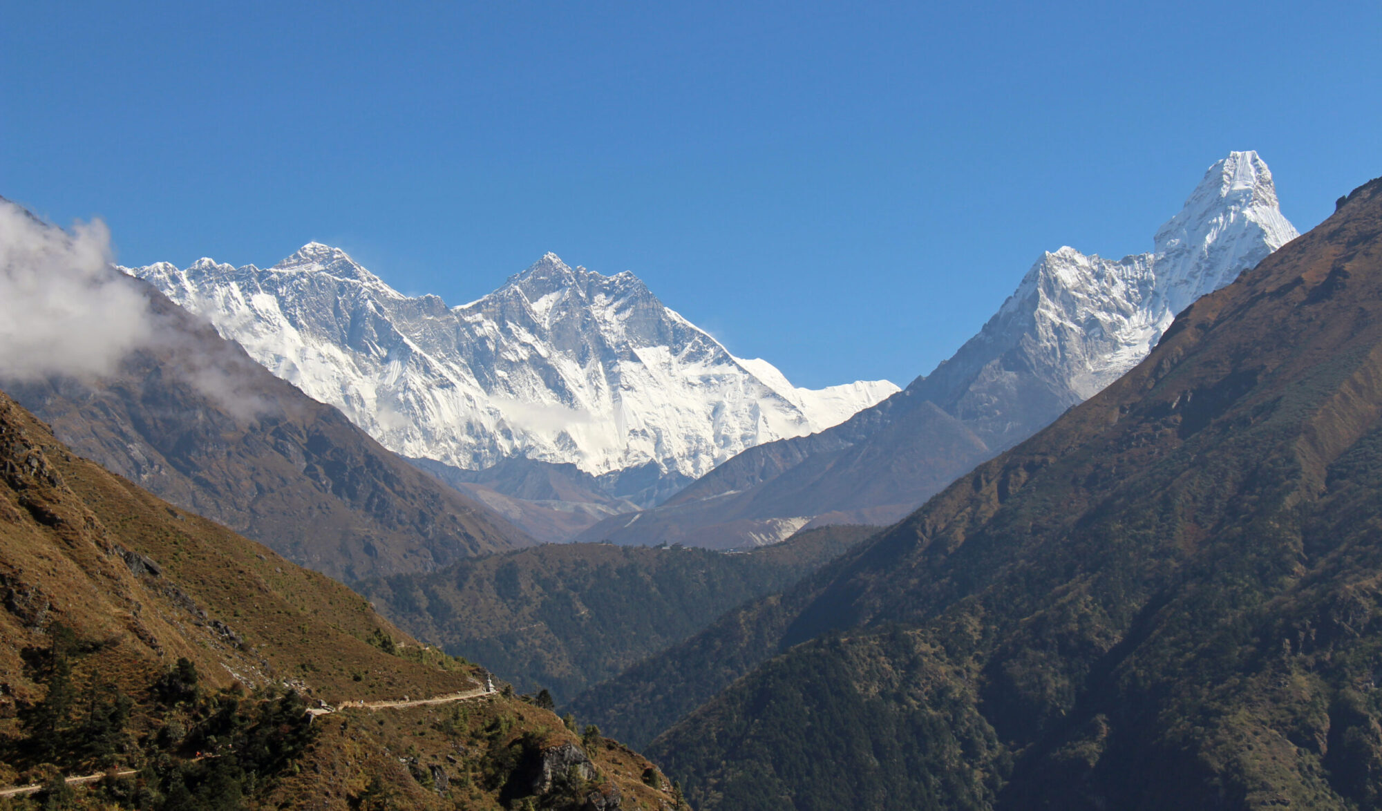
After the first bridge the gradient starts to kick in and once past Dove Falls and across the second bridge the uphill section starts in earnest. Ahead, Dove Crag, a fortress of rock, sheer and imposing dominates the view. It’s Grey cliff face is nicely contrasted between Dovedale Beck, the sunshine sparkling off its rippling waters and the cloudless expanse of blue sky above its crags. The only other people I see on the way up are five young guys who look weighed down with equipment and tell me they are on their way to the Priests Hole.

My walking style tends to be slow and steady without much stopping and it isn’t long before I reach the stone steps which mark the steepest section of the ascent. Into crawler gear up the steps and soon I reach the head of the valley with the gradient easing off as I enter Houndshope Cove. The cove is a flat marshy plateau between Dovedale and the rising ground beyond that leads up and onto the Fairfield ridge.


Before this second climb I park myself on a rock for a rest, a bite to eat and to admire the views all the way back down Dovedale and over to Place Fell, High Street and the rest of the Far Eastern Fells. It’s here that the path to the Priests Hole cave diverts off the main path and I can see, or more precisely hear, two guys far up the crag looking for the cave and shouting directions to each other.

From the cove, the path heads upwards again, not so steep this time, meeting the Fairfield Horseshoe ridge at a cairn in between Dove, and Hart Crag. A right turn along the ridge takes me up the rocky path and onto the summit of Hart Crag.

It’s Sunday and there are a fair few people out taking advantage of the good weather. Whilst on Hart Crag two groups of fell runners go past me, each group about twenty strong and I wonder if there is an event on as other single runners continue to go past me, all clockwise, coming from Fairfield.
There are good views from the rocky top of Hart Crag all the way down the Rydal Valley to Windermere Lake and Coniston Water. The Coniston fells, Scafell range, Bowfell and the Langdales all standing out in the clear air. A short distance away is the summit of Dove Crag, where I stood in the snow and brooding clouds only a few short weeks ago. With cloudless blue skies and unbroken sunshine, the weather today couldn’t be any more different.

The path drops slightly off Hart Crag and then rises up again to a prominent cairn which seems to mark the top of Scrubby Crag. From here the path to Fairfield is clearly seen, wide and obvious, bending its way around the head of the valley and up to the summit. In mist it would be easy to go astray on the wide flat summit plateau of Fairfield but there are no such problems today. Just past the cairn, before the path leaves the ridge edge there is a good view all the way down the valley to Windermere and beyond. The curving horseshoe shape, with the green Rydal valley far below is seen to its best effect here and the whole of the classic Fairfield horseshoe can be made out.


The summit of Fairfield sits away from the edge across a flat area of stony ground marked with a number of cairns. It isn’t long before I am at the summit, although summit may be pushing the description a bit as the whole top is about two tennis courts of flattish ground with a number of cairns staking their claim to be the top.

I settle on one of the cairns and get my pack off. Fairfield is pretty high and, although not particularly central, on a clear day like today offers a grand 360° view of the Lakeland mountain panorama. There are a few other people on the summit with me but because it is so broad and flat it doesn’t feel crowded and we all seem to have a cairn to ourselves.

After some time admiring the view and eating lunch I head over to have a look at the best line of descent to Cofa Pike. I knew Cofa Pike was a little bit ‘scrambly’ and had read a couple of weeks back of a guy who took a nasty tumble on it so I switched on to safety mode. The direct route from the summit of Fairfield to Cofa Pike, (marked on the OS map) was a little steep for me but I easily avoided it by veering left onto an easier angled descent (also marked on the map).

After this I took a path that went to the right of the main top, hands were needed on a couple of occasions, mainly for my own assurance rather than necessity. There were then a number of routes to choose from but I veered left of another rock outcrop and over a few more rocky sections before it opened out onto the broader fell which I followed down to the small cairn that marks the start of the descent path at Deepdale Hause.

I had had a look at Deepdale as a return route to Patterdale after climbing St Sunday Crag some months ago but settled on Grisedale so I was looking forward to walking down a valley that was new to me.


It was a pretty steep drop off the Hause down into Sleet Cove but this was short lived and the gradient eased off after a couple of hundred metres as the valley floor was reached. After the exertions of Cofa Pike and dropping into the valley I stopped at the sheepfold that is marked on the map and enjoyed sitting in the stillness and quiet of the valley for a while, the afternoon sun warming me as I admired the grandeur of the huge crags and rock faces dropping straight down from the summits of Hart Crag and Fairfield. These vertical rock faces have names like Black Buttress, Hutaple Crag and the most impressive of them, Greenhow End. They are however a sight never seen, and perhaps never even known about by the many who tackle Fairfield from Ambleside and see only its softer side.


From the sheepfold I follow the track which is feint in places as the path is not well trodden, as it wound its way down Deepdale, passing waterfalls and around glacial moraine mounds, reminders of the last ice age when glaciers filled these valleys ten thousand years ago. About half way down, the path meets up with Deepdale Beck and is followed down the widening valley until, after what seemed like an age a stone bridge is crossed and I arrive at Wall End Farmhouse. From Wall End I follow the farm track past Deepdale Hall and down to the main road at Bridgend.

From Bridgend there is a very short section of road until I reach the footpath that goes through Low Wood. Although the path is never far from the road it provides a pleasant route through the woods, with birdsong keeping me company back to Cow Bridge. It was a long walk down Deepdale and through the wood but my spirits are lifted when Brotherswater comes into view, still and calm in the late afternoon sun and perfectly set amongst the various ‘Dodds’ that cluster around the bottom of the Kirkstone pass.

Past the lake, left at Hartsop Hall and I am soon back at the campsite. Sitting outside the van with my boots off, cup of tea in my hand, warming myself in the sun and surrounded by the hills and valleys I had walked that day I consider myself a fortunate man to have been able to enjoy another days walking in beautiful Lakeland.
To Find All My Walks In The Eastern Fells Click Here
For a map, route details and picture gallery of this walk click ‘Learn more’ below