

Day Three Mintaro Hut to Dumpling Hut
As forecast we awake to a completely different scene from the Sunshine and clear blue skies of yesterday. Cloud and mist have descended low into the valley overnight, draining the colour from the trees and muffling the sound of the birds and the rivers. The huge rock wall of Mount Balloon opposite which last night rose up before us like a giant is completely enveloped in mist and may as well have disappeared as far as we were concerned as we could see nothing beyond twenty metres. The air was still and the mist, cold and damp, hung in the air. It was like a grey wet blanket had been thrown over the valley.
After breakfast we get ready for the day ahead and I’m thankful that I remembered to hang my boots securely on the pegs above ground level. The Kea, huge parrots that are only found in the Southern Alps of New Zealand were seen around the hut. They can’t hover but have been known to make off with boots left carelessly on the ground.
*Click on any image to open larger in new window*


Once we sort our kit and set off it’s not long before we arrive at Lake Mintaro, a small lake not far from the hut of the same name. The lake looks ethereal in the morning mist which has brought silence to the forest, the birds seem to be keeping their heads down under the blanket of cloud. The mist dampens our clothes but it’s not actually raining so I hold out some hope for improvement if the sun can manage to come out and burn off the cloud.

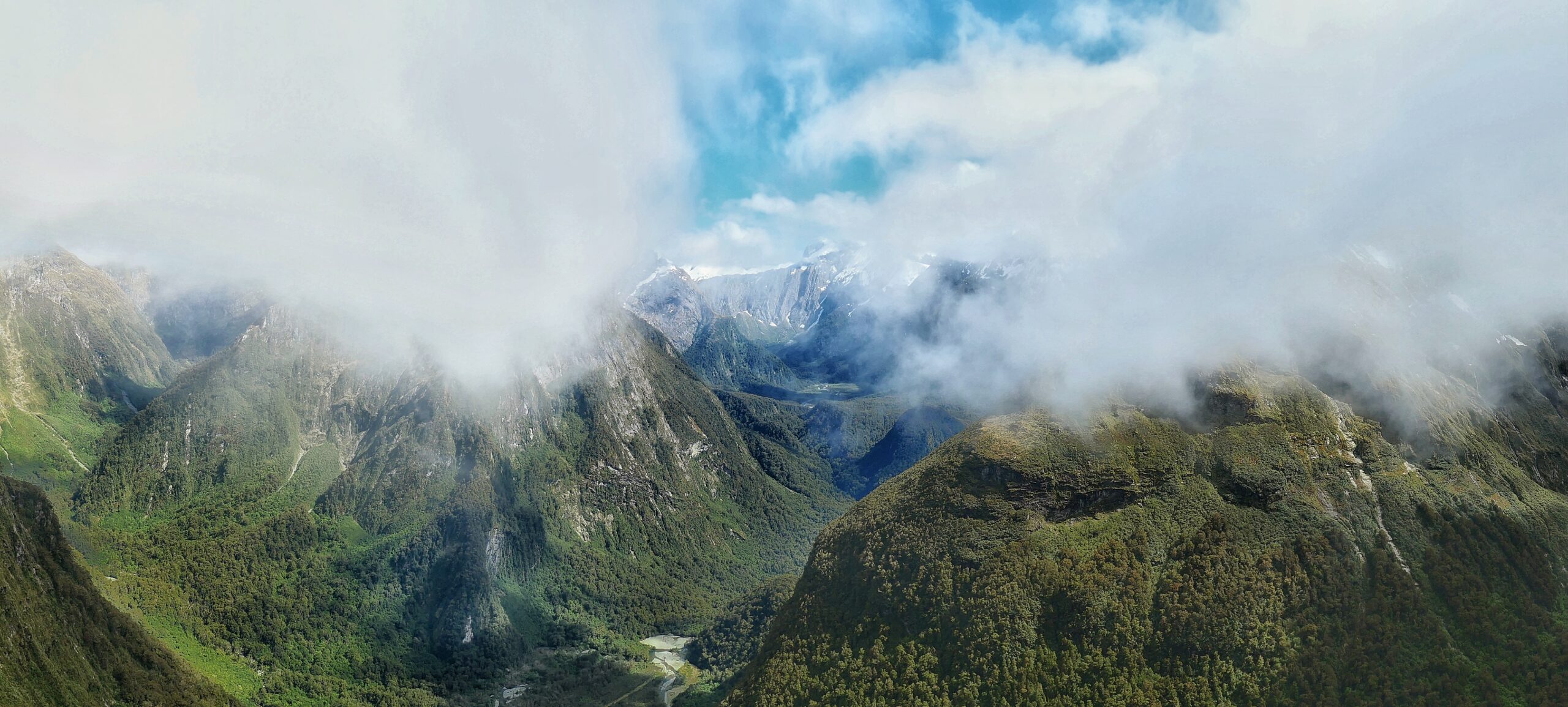
Past the lake there is a flat forest section and then we cross ‘the wobbly bridge’ as Clive describes it. It’s our final footbridge over the Clinton river, which has been our solid companion of the last three days and shortly afterward the climb up to the Mackinnon Pass starts in earnest. Today is the high point, literally, of the whole track, the day we climb up to the Mackinnon pass, the highest point on the walk. Crossing over the pass takes us from the Clinton valley to the Arthur river valley. From the landward side of the walk to the seaward side. It’s also the day we will see New Zealand’s highest waterfall, Sutherland falls. But all that is ahead of us as we start the slow trudge up the track, which turns to zig zags as the incline steepens on the approach to the head wall of the valley. The path up to Mackinnon pass is steep but the zig zags mean the gradient is good and we soon fall into a steady rhythm as we ascend slowly higher with each step. We are still walking in the cloud but there are occasional, teasing glimpses of the Clinton valley below us when the cloud breaks.

As we climb higher I notice that the sky is beginning to lighten and I am hopeful that at some point we will climb out of the murk. After an hour or so of grinding it out on the zig zags we finally arrive at the Mackinnon memorial just as the cloud starts to break up and the morning sun, not seen so far today begins to shine through and welcome us. It is perfect timing.

Gwen and I drop our packs and have a good look around. The Mackinnon pass, at 3,786 feet is not particularly high but being at the head of two valleys it affords some magnificent views and as the clouds are now in full retreat, being burned away by the warming sun the views become increasingly clear. The Mackinnon memorial is the significant feature of the pass. It’s a large rock cairn with a plaque that reads “In honour of Quintin Mackinnon, Explorer, who discovered this pass in 1888 and who in 1892 was drowned in Lake Te Anau”. Twenty metres from the monument the path literally comes to an end with a vertical drop straight into the valley below. There is a useful sign telling you to stop walking! From here the view is quite simply sublime.

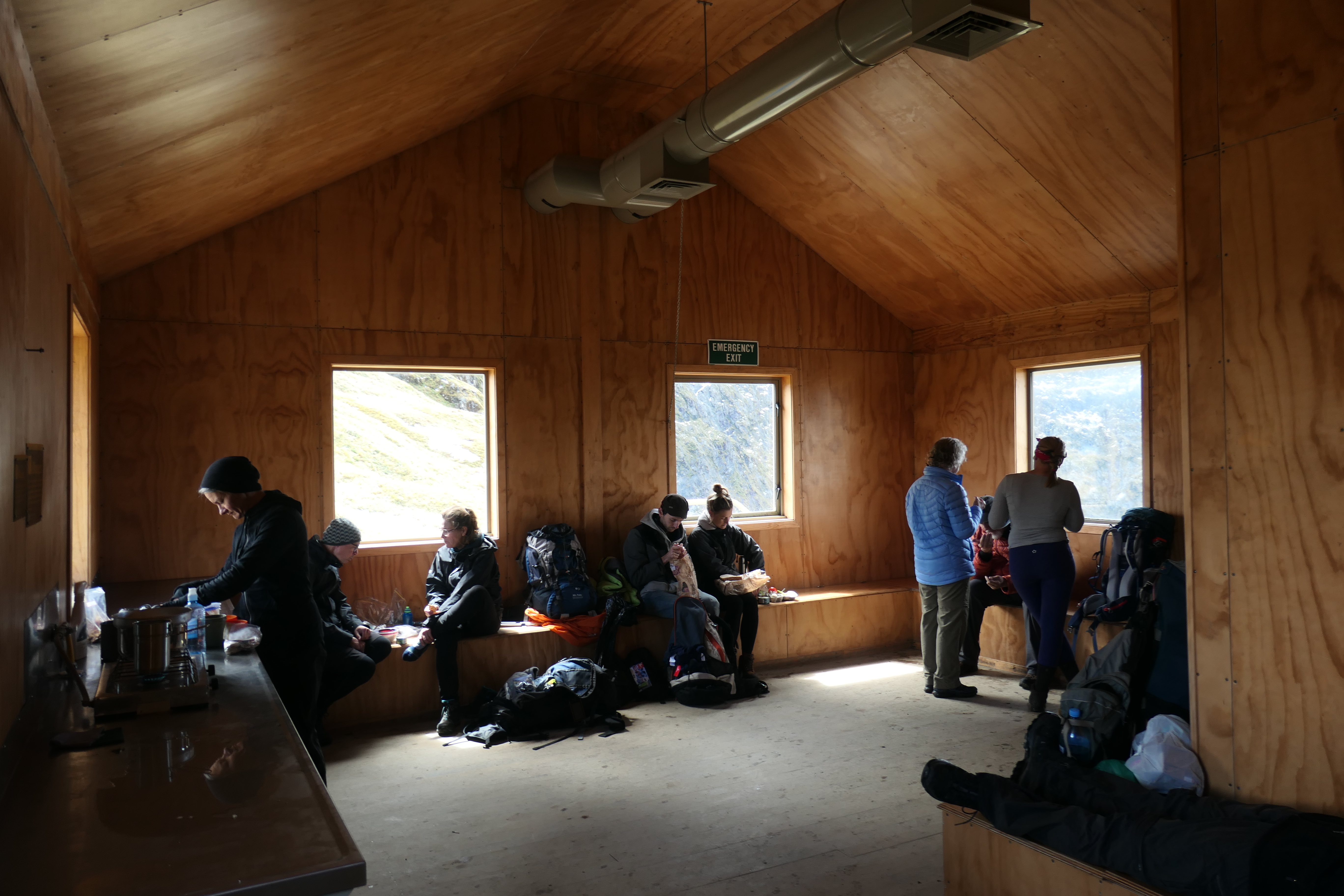
The rich, deep forested carpet of the Arthur and Green valleys rise steeply up the green mountainsides with cascading waterfalls all the way to sharp snow powdered peaks and ridges which stretch out in front of us as far as the eye can see. Above them is an increasingly blue sky. It’s a beautiful site. It’s hard to break away from standing in awe of the scenery but we still have a way to go and so, after taking plenty of pictures we put our packs back on and make our way over the high point of the pass, which still has some snow on the ground to the Mackinnon pass shelter where we can enjoy lunch under cover. According to Clive, the warden at Mintaro this is the fifth shelter, the other four having been blown away in storms over the decades. The shelter is definitely an ‘us’ and ‘them’ place. Them, the guided walkers get a room of their own where presumably a full buffet is laid on with cigars and brandy to finish. Us, the independent trampers get a plywood room with benches and a couple of gas burners. The toilet is the great leveler though, bringing the ‘haves’ and the ‘have nots’ together in a way that Karl Marx would be proud of to all enjoy the toilet with possibly the best view in New Zealand.

After lunch what remained of the cloud cover on the mountains has vanished and from the shelter (and the toilet!) there are wonderful views all the way down the length of the Clinton valley. From here it’s technically down hill all the way to Dumpling hut although that doesn’t mean the walking is easy and as we intend to visit Sutherland falls there will still be some climbing. From the shelter the trail heads north passing the huge arête that leads up to the summit of Mount Balloon, 2,000ft above us.
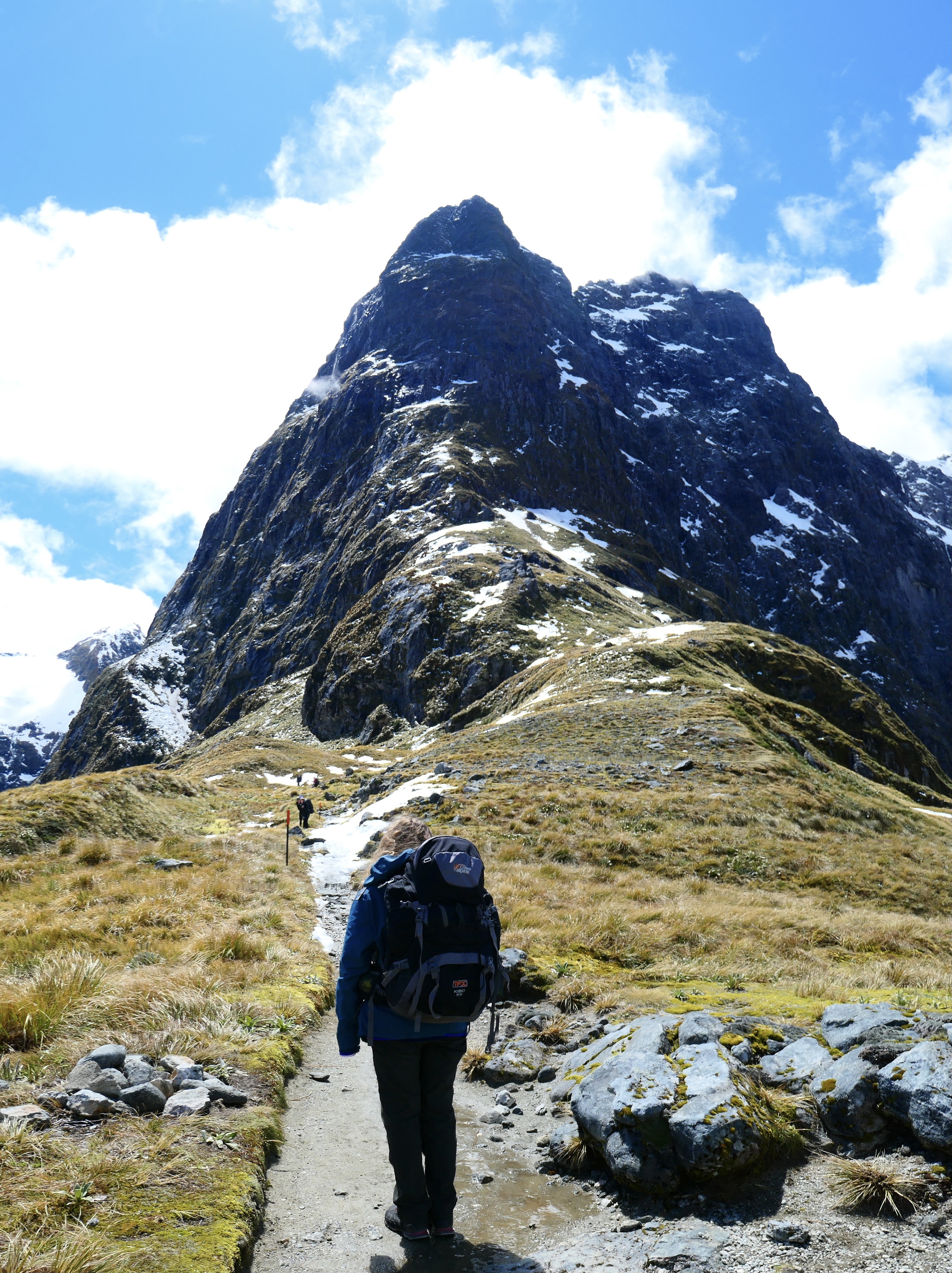

The path heads down on a slow incline but after half an hour we are stopped from walking the main path and diverted onto the emergency track because of avalanche danger. As we head down the emergency track we can hear rock falls down the mountainside where the main path passes underneath so are pleased to be avoiding this danger. The emergency track is shorter but much steeper and rougher than the main track and with the sun now high in the sky and the temperature rising is hot and tiring work so I am glad when we pick up the main trail again just north of Anderson’s cascade shelter.

The walking that follows is a waterfall lovers heaven as the track follows the Roaring Burn river on a series of wooden staircases down through the forest passing a long succession of fast flowing, crashing, dashing and indeed roaring waterfalls all the down to Quintin Lodge. Quintin Lodge is the guided walkers hut but it also has a day shelter for the use of independent trampers with water and cooking facilities. It’s also from here that the Sutherland falls diversion starts. When I open the door to the day shelter we are met by the now familiar faces of some of our fellow independent trampers and we get to catch up on the day and how great the views were from the pass.

Most of us present are intending to make the journey up to Sutherland falls. Even though it adds an hour and half to two hours on the day, as Clive, the warden at Mintaro hut said last night “if you haven’t walked to Sutherland falls, you haven’t walked the Milford Track”. Gwen and I have a rest at the shelter and take the opportunity to replenish our water and have a bite to eat. Since the clouds cleared on the pass the sun has been back out and the temperature creeping up through the day. I also cheekily offload all my rubbish into one of the rubbish bins supplied in the shelter. As independent trampers, what you take in to the Milford Track you also have to walk out. This includes all your rubbish as there are no bins in the independent trampers huts. This obviously doesn’t apply to the guided walkers so I figured nobody would mind if I lightened my load, in another spirit of Marxism at the ‘posh’ hut. Gwen and I leave our packs in the day shelter and walk the trail up to Sutherland falls. It’s a steady walk up through the trees on a slow incline.


You hear the falls long before you see them and the first sight, through the trees is impressive. The falls drop fairly vertically, 904ft over three ‘leaps’. You can get up close and the roaring power and spray of the water, together with the noise and wind generated takes your breath away. It also gives you a good soaking but after the hot walk down from the pass I find the cold spray on my face quite refreshing. Sutherland Falls is New Zealand’s highest waterfall and I feel quite privileged to see it as it is only those who walk the Milford Track (or presumably pay for an expensive helicopter) who have the honour of seeing it up close.
Back at the day shelter we steel ourselves up for the last section of the day, the hours walk from Quintin lodge to Dumpling hut. The exposure of the emergency track and the warmth of the afternoon has left me a little dehydrated so I fill up both water bottles at the day shelter and determine to drink it all before the end of the days walking. About twenty minutes after leaving Quintin lodge there is a good long distance view of Sutherland falls to be had through a break in the trees.

The last hours walking passes quite pleasantly. As we have now left the guided walkers behind at Quinton lodge the trail is quiet and peaceful and I get lost in my thoughts as we follow the track, which winds its way through the beech forest with only the ever present sound of the birds and the tinkling water of countless streams for company. The arrival at Dumpling hut breaks the spell of my quiet contemplative walking and we are soon into the now familiar routine of finding a bunk, noting its number and signing into the reception book before unpacking and settling in for the evening. Dumpling hut has smaller capacity rooms than Clinton and Mintaro huts and we are in a ten bed room with six Americans, a couple and a family of four, and a Dutch couple. The sandflies are out in abundance at Dumpling hut and once again we are thankful that we packed the mosquito nets.


We chat to the Australians over dinner and then Jules, the hut warden provides the customary after dinner speech with a story of how Messrs Mackay and Sutherland tossed a coin to see who would get to name Mackay falls agreeing that the next waterfall they found would be named after the loser. Sutherland lost but in the end really won because the next falls they arrived at just happened to be New Zealand’s highest. I’m up a couple of times in the night because of my fluid intake but I don’t mind as it gives me the chance to gaze up into an inky black cloudless sky, marvelling at the multitude twinkling stars of the Southern Hemisphere, its constellation patterns an unfamiliar site to my northern eyes.
To Find All My Walks In New Zealand Click Here
Route Map, Walk Stats and 3D Flyover of Route Below
One Reply to “Milford Track – Mintaro Hut to Dumpling Hut”