

Before starting my book by book journey through Wainwright’s iconic 214 I had climbed many of them before, one hundred and one of them to be precise. Coniston Old Man was one of those and my walking journal tells me I climbed it on Friday 14th August 1987 with a couple of other guys and the weather was clear. To be honest I don’t remember much about that walk but the 80’s and early 90’s were years when long social evenings in the pub were as much a part of any visit to the Lakes as the walking itself so that may account for my somewhat hazy memory.
Thirty eight years later I’m back to climb Coniston Old Man for the second time. A man lives many lives in one lifetime and each season brings its own joys and challenges. The young, carefree days of 1987 with no thought of getting old or unhealthy have matured into a more circumspect attitude to life as I reach my late middle age.

Time is a diminishing resource and I certainly have far less now than I did in 1987 so these days I do my best to keep healthy, keep moving and make the most of the time allocated to me. Coniston Old Man doesn’t worry about time though, it’s timeless, and the weather is as clear today as it was on my first ascent.

As I walk through the picturesque village the shops and cafes are just starting to open up on what is another dry and sunny day. I pass by St Andrews church and it’s lovely Yew tree, cross the road bridge and head up and out of town on the back lanes bordering Church Beck to join the footpath at Miners Bridge by Coniston Waterfall.


Beyond the bridge the Coppermines valley opens up. Copper was mined in the valley for centuries, possibly since Elizabethan times and the remnants of its industrial heritage, machinery and long abandoned quarries scar the hillside. Notable is the White painted youth hostel which used to be the mine managers house.

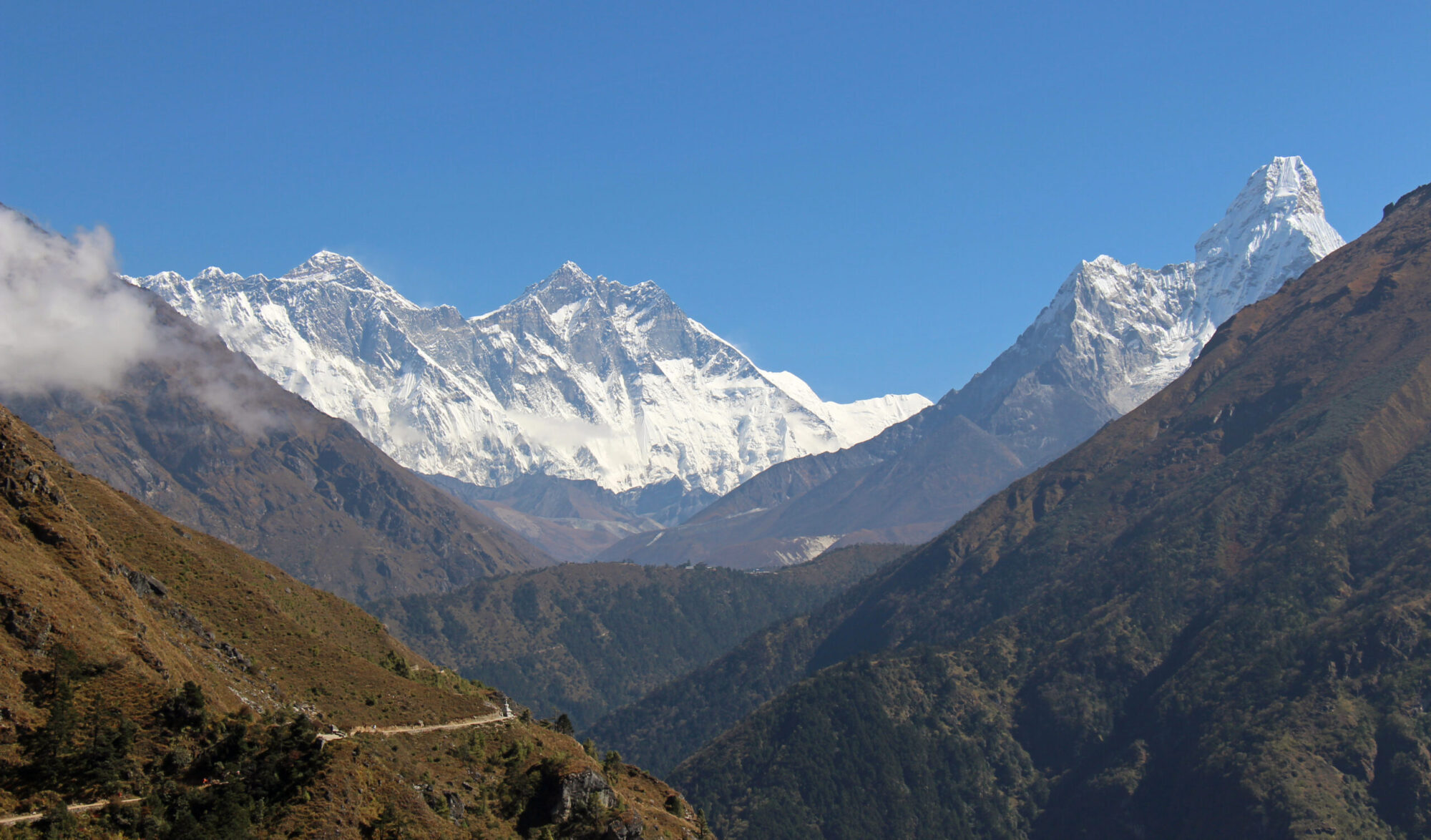
The path angles up the hillside away from the river and joins an old quarry track at Crowberry Haws. From here it’s steep walking all the way to the top but the views are crisp and clear and there are some points of interest on the way that provide natural rest stops.

Before long I arrive at Saddlestone Mill. There is a sign saying 1690-1960 on a wooden support and the remains of winding gear, cables and railway tracks that were used to haul slate quarried out of the heart of the mountain. There are caves that can be explored (with care!) but I like to have the sky above me so I forego the pleasure.


Another steep section follows up to Low Water and another chance to take a breather along with the scores of other people who are climbing the Old Man today. Coniston Old Man is a Lakeland honey pot hill, having some magnetic appeal that draws people who would not normally consider climbing the stairs to put their trainers on, pack some Kendal Mint Cake and walk uphill for two and a half thousand feet to its summit.


One final climb up a zig zag path takes me to the top and it’s easy to see why Coniston Old Man is such popular mountain. To the east the ground drops away, plunging steeply down all the way to Low Water giving a great sense of height and space. Beyond Low Water the route can be traced all the way back to Coniston village, by now no doubt bustling with shoppers and tourists. The village is surrounded by green pastoral fields which contrast nicely with the blue streak of Coniston Water. Being on the southern edge of the district Morecambe Bay and the Irish Sea are prominent to the south and the whole of the rest of Lakeland lies to the north.


After taking in the view and having a bite to eat I head off along the easy ridge leading to my second summit of the day, Brim Fell. I say summit, in essence it’s just a rise along the long ridge leading to Swirl How further north.

It is however adorned by one of the best cairns I think I have ever seen in Lakeland. A tall and very neat conical shaped mound of rocks marks the top, obviously built with care and attention by somebody, probably more than one person, many years ago and it stands today as a fitting testimony to them.
My next hill, Dow Crag is less than a mile away and fifty feet below me. Unfortunately it lies across the deep hollow of Goats Hause, containing the (as yet) unseen Goats Water. So, like the Grand Old Duke of York I will have to march down five hundred feet only to climb up four hundred and fifty feet to reach its top. Such is the nature of hillwalking.

The dark and imposing grey buttresses of Dow Crag’s east face are well defined against the blue sky and look mighty impressive. Dropping three hundred feet straight down from the summit into Goats Hause these six unimaginatively named buttresses (A to E and Easy) provide dozens of climbing routes of varying grades. The routes themselves have more imaginative names such as Leopard’s Crawl, Hopkinson’s Crack and The Shining Path.

Leaving Brim Fell I take the direct route to Goats Hause joining the well trodden path from the Old Man further down. A small cairn, with a good view of Goats Water sitting in its little hollow marks the start of the path leading down to the tarn and eventually back to Coniston. I have more work to do however so put my head down and march up those four hundred and fifty feet to the summit of Dow Crag.

I’m not a purist when it comes to summits, I know when I’m on top of a mountain and don’t feel any great need to touch a cairn or trig point to prove it. The very top of Dow Crag however is a small blocky tower of about twenty feet which I feel is a bit much to leave out if I’m going to satisfy myself I have reached the summit. So I stash my poles and scramble up the rocks until there is only air above me.
From Dow Crag the walking is delightful. A high level ridge heads south crossing over Buck and Brown Pikes with superb views across the chasm to Coniston Old Man and down to Goats Water.


At Brown Pike I take one last look back along the ridge and then drop down to the Walna Scar Road, one of many ancient packhorse routes in Lakeland that probably sees more footfall today from hikers than it ever did in its previous thousand years of existence.

Once on the road, which is obviously not a road but a rough stony track it’s a steady and pleasant downhill walk three and a half miles back to Coniston with nice views of Coniston Water ahead and, further down the track Dow Crag, whose buttresses look more intimidating when seen from below.


The tarmac is joined at Walna Scar car park which today is full to bursting with cars, and an ice cream van, which on this baking hot day has a queue stretching the length of the car park.
Route Map, Walk Stats, Geolocated Pictures and 3D Flyover Video Below.
Click ‘Learn more’ on the map. Note: you won’t see the map if reading in WordPress reader but can view it on the browser.
Ages since I’ve been that way. Must get out more!
Thanks John, I’d forgotten how lovely the southern lakes and Coniston village is
The Old Man was the first Lakeland hill I ever did.
Sounds like a return visit would be pretty memorable
It would – and I’m not that far away.
Walna Scar looks like a chalky snake. Fabulous, and Itoo need to get back up that way.
It does doesn’t it! I think I was too tired to notice but the picture makes it stand out 😀
What an interesting walk, so much to see!
Thanks Ej, yes lots of history and great views 😀
Wow, certainly some amazing views Jim and I agree, the cairn on Brim Fell is spectacular. Where’s next?
Thanks Gilly, I’ll keep chipping away at the Southern Fells aiming to finish them maybe in the autumn if time allows and the weather is kind😀
I’ve done the Old Man and Brim Fell twice now. Like you once we headed off to Dow Crag, a superb mountain. Second we carried on to Swirl How and down Prison Band. Either way the area is superb and I remember looking down at Caw and Stickle Pike and wanting to head that way as well. Return visit needed
Thanks Steve, yes great mountains with fantastic views, and I forgot how lovely Coniston Village is 😀
What a beautiful weather for a great walk. The old man is the first summit in the lake district we climbed. That was around 8 years ago. We went up by Goat water and down by the old mine.
That’s funny Mél as John Bainbridge has commented on here that that was his first hill as well! Although I think he may have climbed it more than eight years ago! 😀
Great report. The Old Man was one of my early ones. I still haven’t done Dow Crag and it will have to be done as a single, as will Wetherlam, unless I do a big walk.
Wondering what counts as late middle age though (I’m 56..)
Thanks Tessa, I think 56 would qualify as early to middle middle age 😉