

It’s always nice to start a walk straight from the campsite and Chapel House Farm has the added benefit that I can have breakfast looking up at my first hill of the day, Rosthwaite Fell. Wainwright dedicates his book on the Southern Fells, the book I’m currently walking through to “The Sheep of Lakeland, the hardiest of all fellwalkers”. In what has been a sustained spell of dry weather these hardy Herdwicks are suffering a little. Richard, the farmer and campsite owner tells me the dry weather has not been good for his flock of a thousand Herdwicks who are suffering from the lack of water and parasitic infestations growing in their wool. For his livelihood and the sheep’s well-being I hope Lakeland has some rain soon, maybe just not today.


From the campsite I head up a walled track that skirts the north western flank of Rosthwaite Fell below the crags of High Buck How. A path then leaves the track and rounds the hillside curving into The Combe, a narrow valley that leads up to Combe Head and contains Combe Gill.


Passing through a gate I reach the open fell side and start heading upwards. The path soon peters out and I have to find my own way to the gully of Dry Gill, which true to its name is all but dry. Here I pick up a feint path on the far side of the gully that heads upwards steeply following the line of the Gill. Although the incline is severe the ground under my feet is soft easy grass where a nice rhythm can be established and maintained.


At the top of the Gill the gradient eases slightly and I traverse right to avoid a rock bluff in front of me. It turns out left would have been better as I find myself further away from Tarn at Leaves and have to walk back on myself.

Tarn at Leaves is essentially a reedy pond in a hollow of flat ground between the two high points that make up Rosthwaite Fell. Wainwright describes it as having “a lovely name but no other appeal” and I’m inclined to agree with him.

The climb up to the top from the tarn is a short one and before long I’m standing on the summit of Rosthwaite Fell. More accurately, I’m standing on the summit of Bessyboot, which is the lower of the two areas of high ground. For reasons known only to himself Wainwright decided that this summit, rather than the higher Rosthwaite Cam was going to be his chosen top. Subsequently thousands have followed the inerrant words of Wainwright, leaving poor Rosthwaite Cam to become the Betamax of fell tops.


The journey to Glaramara from Rosthwaite Fell is a long and winding one across an undulating, featureless, tussocky landscape. Route finding is problematic with the path often playing hide and seek as I make my way over hillocks and around mounds.


Eventually, to my right I can see the rocky bulk of Glaramara rising up from the boggy grassland I have been trudging over. The path avoids a direct assault on the summit and instead works around to the south where the gradient is slightly kinder.

Notable in the otherwise unremarkable walk over from Rosthwaite Fell is an airy traverse across the top of Pinnacle Bield, its steep slopes dropping down beneath my feet to Langstrath far below with views over to Langdale and the Pikes.

About two hundred metres from the top, dark clouds which have been brewing to the south and getting ever closer look like they are going to rain on my parade so I put a spurt on to get some pictures before the rain arrives.

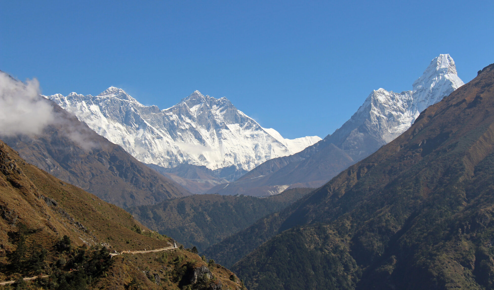
A sprinkle does drop but soon stops and I am left to admire the view from the top of Glaramara in the dry. The proximity of Glaramara to the big hills of Lakeland mean they dominate the view south and Bowfell, Great End and Great Gable are the closest, not looking their best today under a blanket of grey. The skies are brighter to the north and Derwentwater is in sunshine as are Skiddaw and Blencathra.

Although blue sky has returned overhead, the wind has got up and I’m not sure which way the weather is turning so decide not to hang around as I have another three miles of walking ahead of me and don’t particularly want to do it in the rain.

Dropping off the summit I head north towards Combe Head and pick up the clearest, most defined path I have walked on all day. Thankfully the dull weather has stayed behind me and as I start down the broad ridge leading to Thorneythwaite Fell the sun comes out.


Ahead of me, the boot scarred path snakes its way down the ridge. Beyond that, the green and pleasant flat patchwork fields of the Borrowdale valley curve between Castle Crag and Grange Fell leading the eye to the blue paint splash of Derwentwater. The grey stoned market town of Keswick sits on its northern shore and beyond that are the two big giants of the northern fells, Skiddaw and Blencathra. It’s a view that keeps on giving as I tramp down the ridge getting lower with each step. Crossing over Thorneythwaite Fell the path drops back into the confines of The Combe and Combe Gill.

Passing through a gate, I join a farm track which skirts along the eastern edge of the Borrowdale Rainforest National Nature Reserve. After a day on the hill with just the sound of wind and no trees I suddenly find myself in the stillness of the sparse woodland and am surrounded by the harmonious sound of birds which seem to be having the bird equivalent of a ‘rap off’.

Now I would love to be able to say I recognised each birdsong myself but I think we both know that would be a great big fib. Thankfully there is no longer a need to waste years of our lives learning things anymore, Apps and ChatGPT tell us everything we need to know. In twenty years our brains will be mush and we will have lost the ability to think and learn anything for ourselves. In the meantime, Merlin Bird ID tells me I’m listening to a Meadow Pipit, Blackcap, Willow Warbler, Tree Pipit and our old friend the Robin.

I join the Borrowdale road at Strands Bridge and follow it back to the campsite. Late in the afternoon a sound drifts over from the woodland that needs no App to identify. The rhythmic, two syllable high and low notes of a Cuckoo start up, and he keeps going for a good hour until the sun slowly lowers itself beneath the Newland Fells.
Route Map, Walk Stats, Geolocated Pictures and 3D Flyover Video Below.
Click ‘Learn more’ on the map. Note: you won’t see the map if reading in WordPress reader but can view it on the browser.
I feel sure you would have been much better at our Calcedonia walk (next Monday) than we managed, Jim. Rolling back the years doesn’t always work out xx
I’ll look forward to reading that Jo, for me so long as we keep ourselves moving, even if it’s a little bit it’s good not only for our physical but also our mental health, keeps us in a positive mindset 😀
I absolutely agree with the mental part, Jim. We’re going through a rough patch at the moment and escape now and again helps xx
😍x
Fantastic area and I remember dropping off the steep front of Glaramara on my way back to Seathwaite, I wasn’t aware it was there and had missed the loop path around the side. it was a challenging downclimb in the damp weather
Thanks Steve, yes I saw that (it’s the picture looking back) and it looks pretty steep. thankfully I dropped down through a gap to the left of it which then worked its way back round to join the main path below that steep section
I’m a big fan of nature apps. Merlin helps me learn, although my attempts at copying the bird songs would be hugely embarrassing were anyone to be nearby. 🙂
I’m glad it stayed dry for you, but I hope he’s had plenty of rain since 🙂
Thanks Ej, I think there’s been a fair bit since, maybe not enough but the climate is changing and we’re all going to have to adapt with it
I came across Merlin Bird ID only a month ago. I was at my allotment wondering which birds I was listening to – I wonder no more!
Great pictures and narrative once again Jim!
Thanks Dave, yes knowing what the bird songs are adds interest to a walk. Great to have an allotment, they are few and far between these days
That’s quite a hike! I enjoyed seeing the views, most of which would probably be beyond my capabilities to reach. But birdsong I can appreciate 🙂 Yours is lovely, and like you I’m glad to be able to use an app to identify them!
Thanks Sarah, I’m sure taking it slow and steady in good weather many of the hills wouldn’t be beyond your capabilities 🙂 yes being able to identify the bird songs certainly adds interest to a walk
Looks like a great walk. I’m sure I’ll be going back to that area sometime – soon I hope! 🤞🤞😀
Thanks Mike 😀
Glaramara is a lovely name as is Bessy Boot. One sounds romantic, the other quirky 🙂
I’m sure how most of the hills got their names has been lost in the depths of time Shazza and they are such a mixed bunch! 😀
Another glorious path. Thanks for the beautiful stroll. Mel
Thanks Mel 😀
So beautiful!!
Thank you Christie 😀
A beautiful walk Jim. I didn’t know this area of the Lake District.
We definitely had some rain recently 😉.
Thank you Mél, yes thankfully there has been a bit of rain, not great for hillwalking but good for everything else! 😀
The summit of Rosthwaite looks particularly beautiful.
Thanks Ruth and It is beautiful, I liked the look of the picture and possibly got a bit carried away with the editing though