

Over the last few years I have become familiar with every twist and turn of the A592 and A591 as I have tramped over the Eastern and Far Eastern Fells. Today, I’m driving down the B5289 into lovely Borrowdale. Excited to be making progress I feel like an early pioneer heading slowly westwards into new territory. And road numbers aren’t the only change. I survived on mostly van meals in the more remote fells but the fleshpots of Keswick and Grasmere are already tempting me with easy access to beer and steak, coffee and cake. Like Odysseus I must resist their siren call if I’m not to finish the Central Fells heavier than when I started.
Today’s walk takes in Great Crag and Grange Fell and I start in the village of Rosthwaite. Although new on my ‘book by book’ journey it’s a place I am familiar with and have happy memories of staying in its hostel over the years. In those days, the Scafell Hotel was our favoured drinking hole but it closed in January and is up for sale, the previous owners having retired. For £1,500,000 it’s yours.

I stop by at St Andrew’s, Borrowdale. A place of worship has existed here since the 13th century and this church was consecrated in 1687. A lovely Yew tree spreads out in the graveyard and Bob Graham, a Lakeland icon and creator of the ‘Bob Graham Round’ is buried here. The lane leads to Stonethwaite but I turn off before the village, cross Stonethwaite Beck on a bridge built in 1890 and onto the Cumbria Way. I’m only on it for about three hundred metres before the path leading up Great Crag branches off.


The rain of the morning has gone and sun is starting to appear through the clouds. A good stone stepped path leads me up through quiet, mossy woodland next to the amusingly named Willygrass Gill. I pass two large and seemingly unnecessary cairns on the path, remnants perhaps of a time before the path makers arrived.


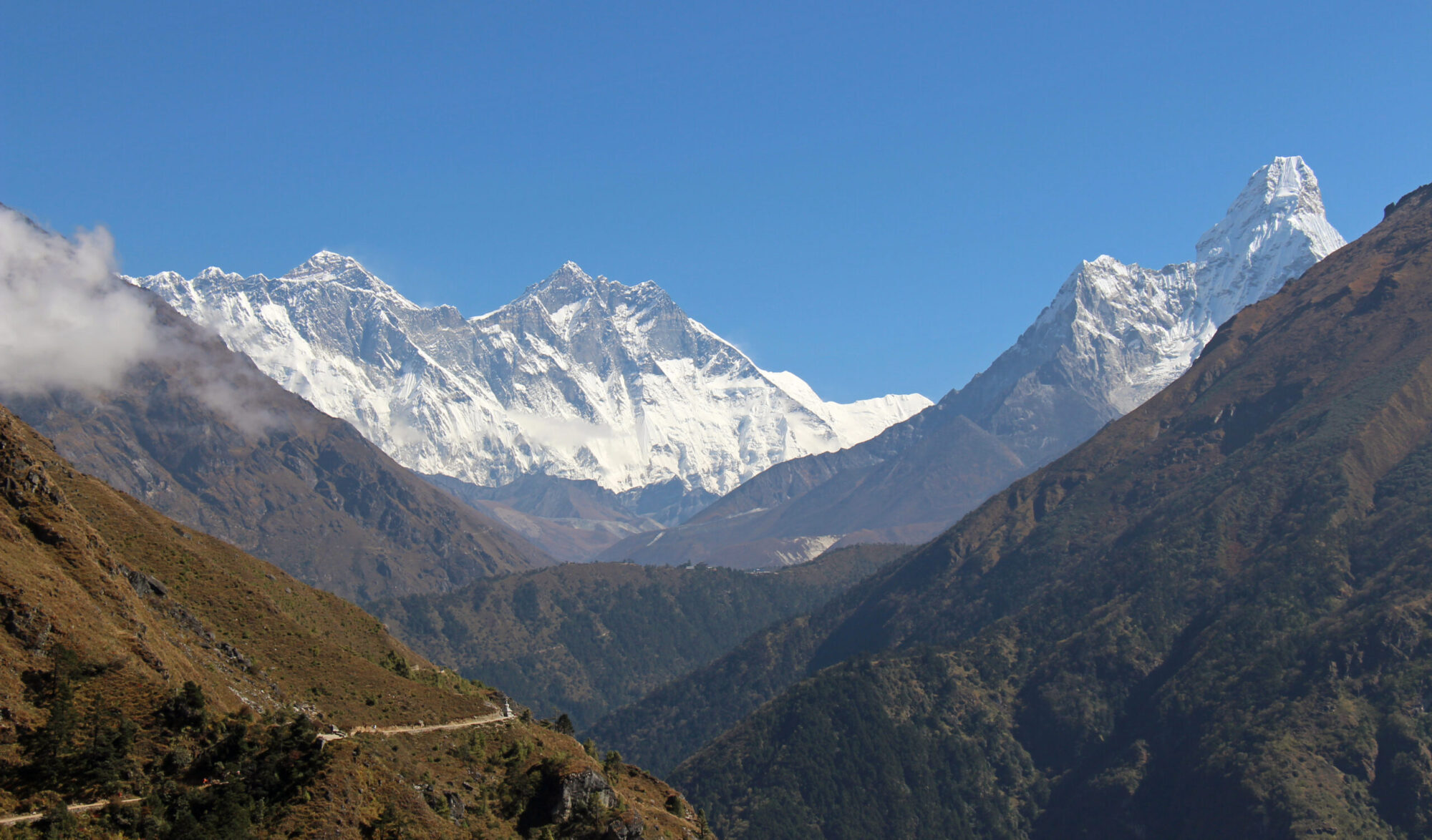
The steps continue up through forest and only end when I leave the trees at Lingy End. In the open I can now admire the views. Eagle Crag and Sergeants Crag are the dominant features south and the triangle shape and vertical face of Honister crag is in the west.


I pass an old ruin and the gradient eases as the path meanders through rock bluffs and tussocks to reach Dock Tarn. Wainwright seemed to like Dock Tarn “a place to lie adreaming and life seems a sweet, sweet thing” It must have been a dry day for him but I don’t do any lying or dreaming on the wet spongy marsh.


For the second time in a matter of weeks I seem to have found myself invading the territory of a little bird which flits back and forth in front of me tweeting excitingly. I manage to get a picture but thanks to Ruth at Walking Away who introduced me to Merlin Bird ID I can identify it as a Common Sandpiper, which is a bit of a find according to my daughter who knows a thing or two about birds.


The path becomes a little maze like from Dock Tarn, rounding and climbing over a confusing array of small crags, false tops and bogs until I home in on two tops that seem likely contenders as the summit. Naturally I climb the wrong one first, which to be fair has a better cairn than the actual summit about twenty metres away.

I have something to eat and below me see a group of ten or so elderly walkers wandering in the confusion of rock bluffs and marsh. I expect them to head my way but despite a few looking at the map they head off in the direction of Dock Tarn.
Leaving Great Crag I join the path to Watendlath but veer off and follow the hillside upwards, crossing another intriguingly named feature, Puddingstone Bank and on up to Grange Fell.


Grange Fell also has a choice of tops. The true summit and highest point is Brund Fell, which has a couple of rocky spires but Kings How and Ether Knott also get a mention.


Despite its modest height there are good views of some of Lakeland’s big hitters from the top. Scafell Pike, Great End and Great Gable are all there along with Derwentwater and the two northern giants.
The walk down from Grange Fell is delightful. In contrast to the rock steps of the path up, the path down is in the main, grass and ahead of me are the flat green cultivated farm fields of Borrowdale surrounded by a praetorian guard of watchful mountains.


Set into the wall of the old vicarage is a WWI Roll of Honour naming the men of Borrowdale ‘Who Went Forth To The Great War’. Out of thirty nine men listed on the memorial, ten of them never returned home to this beautiful valley and five of those have never been found. They lie in secret peace in the fields of France and Belgium.

It’s a thoughtful end to the walk and I hope and pray that no other men or women from this or any other place in the land will have to pay the ultimate sacrifice in a futile war again. Sadly, I already know the answer.


On a lighter note, walking through Rosthwaite there was a rather grand wedding reception taking place and further on I pass the bride and groom having a quiet moment to themselves, eyes only for each other among the busyness and ceremony of their big day.
‘Hope Springs Eternal in the Human Breast: Man never is, but always to be blessed’.
To Find All My Walks In The Central Fells Click Here
Route Map, Walk Stats, Geolocated Pictures and 3D Flyover Video Below.
Click ‘Learn more’ on the map. Note: you won’t see this if reading in WordPress reader but click on the little world at the top of the page to view it on the browser.
Brilliant photo of the sandpiper….
Thank you Patricia, it was a fair distance away but it came out ok for the camera I have 😀
What a treat. Grange Fell top looks quite other worldly but it’s a great photo. Glad to see you enjoying the app, now we can all be experts!
Thanks Ruth, I’m really enjoying it and it’s adds something to a walk now I can identify all those strange tweets and squeaks
I love the ruggedness of the Grange Fell area in your pictures. Maggie
Thanks Maggie, it’s certainly ‘bumpy’ shall we say, with a little squelchy added in! 😀
Its a long time since I was last at Borrowdale and yes, it is indeed lovely!
Thanks Dave, yes a lovely valley
That’s another couple of peaks I’ve never visited. So many thanks Jim for sharing these photos.
It’s my pleasure Mike, I’m glad people seem to enjoy them and I enjoy writing up my walks 😀
Yes, many (many) years ago a friend of mine showed me a website which had a whole series of walks done by a guy in the Lakes. Like yours he had photos taken along the walk with text. I think he must have gone out every day, or at least regularly, as there were 10’s of walks on the site. That must be where I got the inspiration for mine. Sorry, I can’t recall the name of the site.
I loved the aerial view of the route you took. Reading and seeing your great photos Jim really made me want to put my boots on a get out there!
Thank you Gilly, glad it’s inspiring you to get out, not too many mountains where you are but plenty of coast!
What a picturesque walk and well done on identifying the sandpiper. Hurrah for Merlin. Lovely foxglove and steps picture.
Thanks Shazza, identifying plants will be my next mission!
Epic scenery! Trip of a lifetime! 🤩
A beautiful walk. I like the Borrowdale valley and Rosthwaite. It is a bit far from Whitehaven otherwise I will go regularly.
Thanks Mélodie, yes Borrowdale is a lovely valley 😀
Walked these two ten years ago I reckon, I have photos of myself and my boys on both fell tops. You’re right about the views to the bigger mountains from both tops, especially like the view along Seathwaite towards Great Gable from up there
Yes, they’re great viewpoints and pleasant hills in their own right 😀
Nice to see we have so many of the same commenters, Jim. Mick uses a plant ID app, which sometimes works better than others. I’m not so patient, but keep telling myself I’ll have a try with Merlin because I’m rubbish at birds. Love the views down through the valley, and yes, I did find Mont S. Michel on your Instagram. Where to in Europe this trip?
To be honest Jo, I think you’re the hub that many revolve around, thanks to your kind sharing of other peoples posts we end up with mutual follows. The Merlin App is really good and enhances my walks as I now know what birds I’m hearing. We’re off to France again but also Switzerland and Germany so looking forward to seeing some new places. 😀
🤗🩵