

Tilberthwaite car park is almost full when I arrive, late in the afternoon on what has been a lovely warm and sunny Lakeland day. There are a dozen or so cars and three or four vans that I figure will be keeping me company overnight. By 8pm however everyone has departed and I have the place to myself. Dusk turns slowly into the ink black night of the countryside, far away from neon, where stars can shine bright. I enjoy a quiet evening followed by the sleep of the saved and the thankful with only the owls and the comforting sound of the newly born Yewdale Beck to disturb the silence.
It’s still empty when I awake and I have my morning coffee outside by the stream, listening to the dawn chorus and watching the sun rise high over Holme Fell into a cloudless blue sky. All is still in the valley and as the sun warms the ground the mist, hanging ethereally in the green fields melts away and the sheep start bleating, no doubt looking forward to another day of eating grass and looking anxious.
I don’t mention the camper van much in my blog but it’s very much part of my journey through Wainwright’s beloved fells. I use campsites but there are plenty of places to stay off site, in the heart of the mountains, where those rare gifts of silence, solitude and time to think can be enjoyed. It’s life enhancing, especially when I get mornings like this one, with the sun shining, the birds singing and the views all to myself.

My objective today is Wetherlam and the path to it starts straight from the car park with steps leading up to and through the long abandoned slate quarries of Penny Rigg. Once this was a hive of activity but nobody has mined slate here since the early sixties and only the spoil heaps remain, a testimony to a long lost industry.

Beyond the mines the land returns to its pre industrial state and I drop down into Tilberthwaite Gill, a small gorge containing Yewdale Beck. Crossing a wooden footbridge, the path climbs out of the gorge and then contours around Blake Rigg into Dry Cove Bottom.

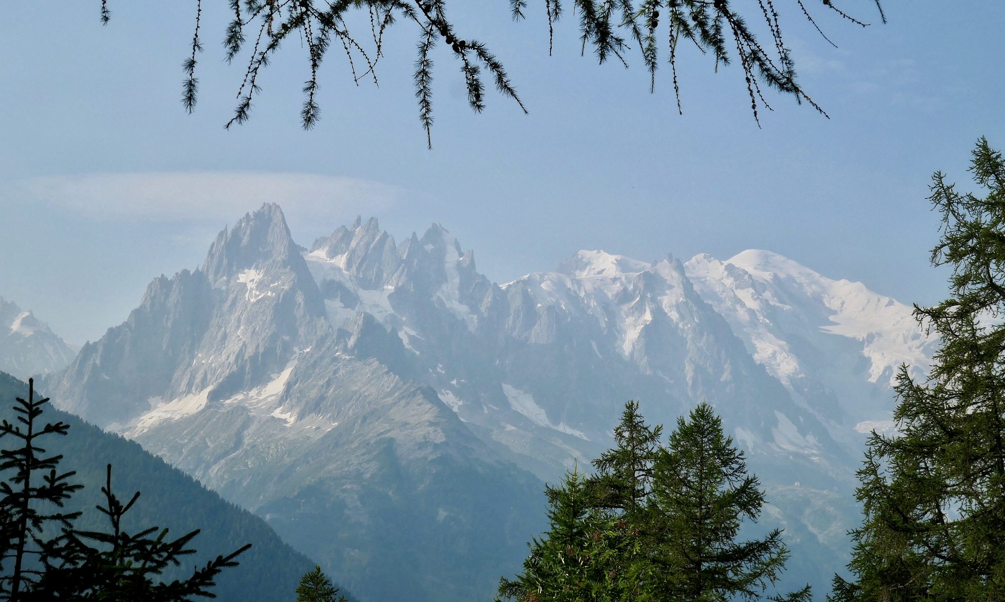
The walking here is very pleasant, a steady upward gradient on a good path with views across the valley floor to the whale back shaped bulk of Wetherlam. As I walk I try and pick out some of the various named crags on its the steep sided face with varying degrees of success.


On reaching Dry Cove, which to no one’s surprise is not dry, my route to the top, Wetherlam Edge, becomes evident and the path heads steeply up the headwall of the valley to meet the ridge at Birk Fell Man.


After a short descent to Birk Fell Hause the climbing of the day begins in earnest. Wetherlam Edge is a fairly steep worn and scrambly path, not always easy to follow and on more than one occasion hands have to be used to negotiate some small crags and buttress’s. In saying that, the ridge is broad and there is no sense of exposure or real danger.


Eventually, after what feels like a full body workout I reach the top of the ridge and the summit cairn is just metres away. The effort is worth it as the view from the summit is superb. Coniston Old Man, the Scafell range and the Langdale Pikes are crisp and clear under a sea of uninterrupted blue sky with no heat haze. Windermere, Esthwaite and Coniston Waters all shimmer and further away, Morcambe Bay leads the eye towards the Irish Sea.
I spend a bit of time on the summit. Partly because this is a series (not that I purposely planned it this way) of one summit walks so I have more time on my hands and it seems a shame to leave such a gorgeous view. Secondly it’s rare, for me at any rate as I tend to feel the cold, to be able to sit on top of a mountain with only one layer on. It’s dry and warm with just a whisper of a breeze. It’s perfect.

Eventually I stir myself and head down the long ridge of Lad Stones heading south. Walking south means I can continue to enjoy the views of Coniston Water and Coniston Old Man ahead of me. The Old Man is my next walk so I have a good look at the route, which looks pretty steep from Low Water sitting in its bowl to the summit tower, standing out against the clear blue background.

After a game of ‘hunt the path’ in the bracken and heather I reach a small reedy and unnamed tarn At Hole Rake and take a break by the still waters.

From the tarn a good path leads down the valley all the way back towards Tilberthwaite.


In Tilberthwaite Gill there are a couple of difficult step downs where I have to wake up and pay attention. One in particular drops ten feet or so to a small platform just above a much longer drop into a stream gully. A slip here and you could easily fall into the gully which would not be good for your health.

Out of the gill, the path becomes easier, levels off and winds through the slate quarries back to the car park, which once again is bustling with people and cars.
Route Map, Walk Stats, Geolocated Pictures and 3D Flyover Video Below.
Click ‘Learn more’ on the map. Note: you won’t see the map if reading in WordPress reader but can view it on the browser.
I’m always with you in spirit, Jim, but there’s often a point at which I think I would not be comfortable doing this. Good that I’m distant, I suspect xx
Thanks Jo, I try and be accurate without sounding melodramatic! I’m sure others (forty years younger!) would think nothing of sections I find a little tricky 😀
Unfortunately I’m in the upper age range and not so brave as I once was xx
We’re growing old gracefully, apparently 70 is the new 50 ! x
A nice summit to spend some time. The trail looks pretty deserted too, even if the parking lot was full. Like here, most people don’t stray more than 100 feet from the highway. Maggie
Yes it was a great day Maggie, it’s one of the less frequented hills and a contrast with what will be my next post, a honeypot hill with a queue of people!
I’ve never done Wetherlam. I obviously missed a trick last week. But then it does give me a good excuse to go back. That scrambly bit looks like fun!
Yes it was a bit of a surprise! I always do a route plan but I’m not a great one for reading up much about the route beforehand which is mostly ok but sometimes catches me out. 😀
One of the best summits I did in my last 30 of the Wainwright’s and one I was glad to do on its own, like you have here. Its one that deserves its own place a belter of a fell. I did it the opposite way to yourself, heading up the more difficult scrambly path and then headed to Steel Edge and then down a very wet Wetherlam Edge, which had brilliant views but was greasy all the way. Love your version of this classic fell
Thanks Steve, I agree. As I was sorting my pictures and writing up my post I think it struck me in retrospect just how good a good walk it was and what fantastic views there are from its summit
Jim, you’ve had amazing weather on your hiking days. Makes for a picturesque view when you reach the top.
A nice round, Jim, I do like Tilberthwaite and Wetherlam.
Strangely, I can’t remember the rocky steps in the path descending the southern side of Tilberthwaite Gill.
Richard
Thanks Richard, yes as I was sorting my pictures and writing up my blog it reminded me in retrospect what a lovely mountain it is, the weather always helps of course!
Stunning views both on the way up and from the summit! I especially enjoyed your 360 degree video, it really conveyed a sense of what it was like to be up there in that perfect weather 🙂
Thank you Sarah, if only the weather was always that good! 😀
I did it from there the first time, nearly thirty years ago. A grand mountain.
It certainly is John, one I would return to, and I can’t say that for all of them
Oh man everything about this day is perfect. Except for the precipitous drop in which I would surely die.
I have every confidence you would not fall into it Ruth! 😀
Wow, such stunning views!
Thank you
What a beautiful walk Jim. It is great that you manage to find some lovely places to park your van overnight.
Thank you Mél, yes there are plenty of places which are not too busy during the week, and more and more campsites I have noticed
Loved your video at the summit. What a view.
Thank you Coral, you’re the second person to comment on the video, I think the clarity of the air has been particularly good during the recent sunny spell, without the heat haze of summer, maybe that’s the difference (or it could be my superb video skills! 😂)
A gorgeous day for a walk, Jim. You gotta love Mother Nature on those blue sky days. Happy trails to you. Mel
Thanks Mel, we’ve had some gorgeous weather here the last month or so, hopefully it’s getting to the south of France!
Seem to have missed this previously. Blimey what a day – stunning views. I haven’t done this one yet but sounds as though I should give your descent route into the gill a miss.
It was just a couple of bad steps Tessa where careful footwork was needed
Too much for a 77 year old?
You’ll know your own fitness level Howard, I would say if you regularly walk up hills in the Lake District this is doable. If you are not a Hillwalker at all perhaps try something easier to start with