

Driving over Birker Fell last night the road started icing up as the sun lowered over the horizon and I wondered at one point if I was going to have to pull over and spent the night on the moor. Thankfully I made it down into Eskdale and after a freezing night under the stars dawn has brought blue skies and watery sunshine, which is providing no warmth at all on the frozen fields but makes for a bright, dry and clear day, perfect for walking.

If you look at any Wainwright map, my objective today, Harter Fell is tucked away in the far south west corner. I’ve not visited Eskdale for decades and had forgotten just how far removed it is from the rest of the Lake District. The honeypots of Ambleside, Keswick and Grasmere are replaced by quieter, less crowded hamlets and villages that are not household names. It’s reminiscent perhaps of a Lakeland in the 50’s and 60’s when Mr Wainwright was compiling his seven pictorial guides or even dare I say one of the 80’s when I was doing my own youthful exploring.
************
Wainwright liked Harter Fell, describing it as “beautiful, especially when viewed from Eskdale”. And now, viewing it from Eskdale I see exactly what he means. The whole of the mountain can be seen from the road and this morning, bathed in the soft buttery light of a freezing winters day it looks very inviting and typical of an artists impression of a mountain.

Flat stone walled fields lead the eye initially towards wooded lower slopes which become brown bracken beyond the intake wall before turning into sheep cropped fell side and finally steep dark grey rocky crags rise up to a definitive top standing out on the skyline.

I leave the road behind at Whahouse Bridge and follow the River Esk for a short while until I reach those wooded slopes. A short amble up through the woods takes me to a footbridge crossing Spothow Gill and then a steep climb following a wall takes me to the main footpath/bridleway coming up from Jubilee Bridge car park.

It is a lovely day with great air quality and clarity and, having climbed up a bit I can now look down on the still frozen fields of Eskdale and across the valley to the giants of the Scafell range which look majestic against the blue sky.


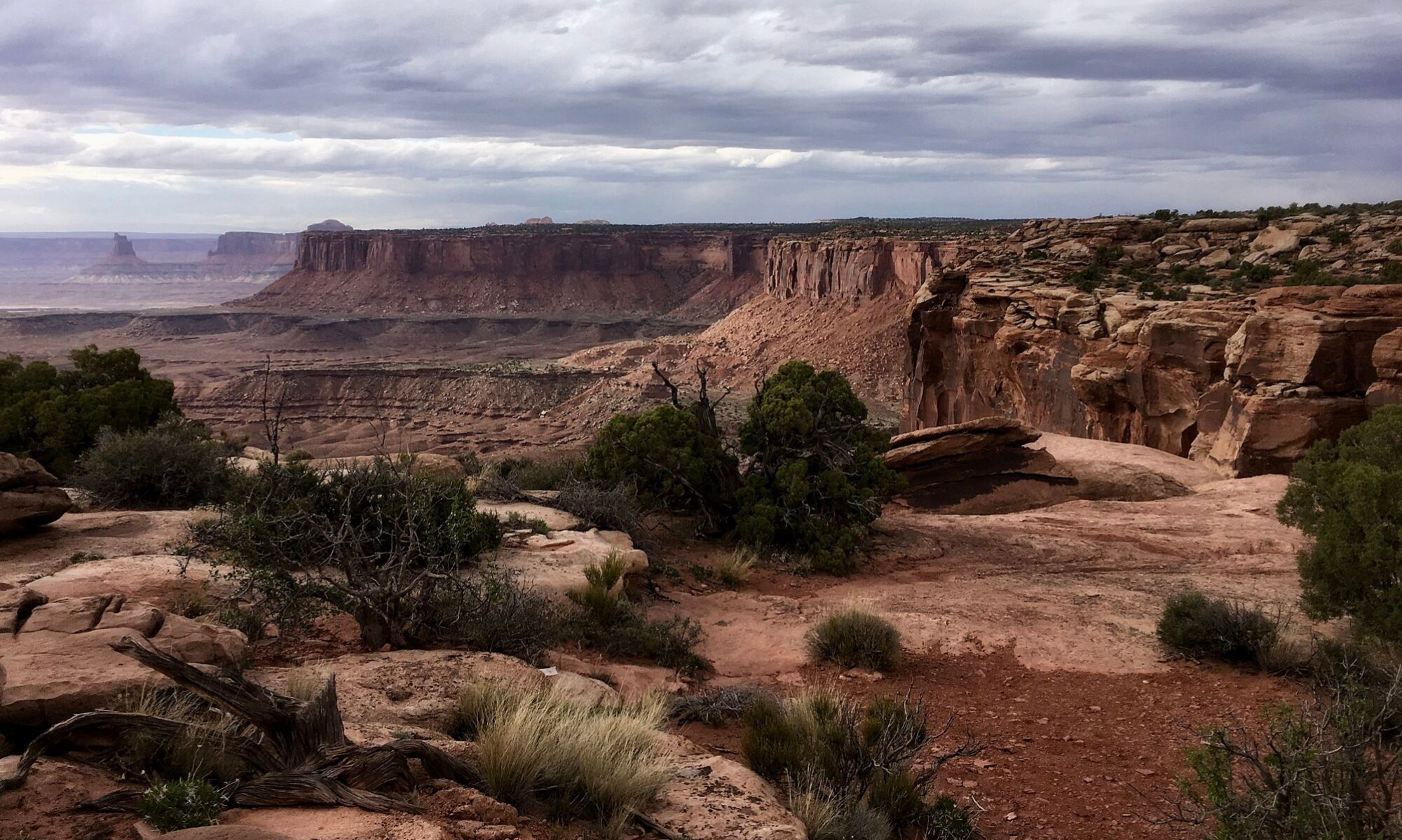
I don’t stay on the bridleway, one of many old packhorse routes for long before branching off onto the footpath that heads up the fellside on a ‘route one’ trajectory to the top.

From the road, Harter Fell looks almost impregnable, it’s top surrounded by steep crags. On the ground however the path weaves its way in between and around craggy knolls and rock outcrops avoiding any difficulties until it reaches the final craggy outcrop upon which sits the trig point.
Heading up Harter Fell


Unusually, the trig point is not the highest point of the mountain. That lies just a short distance away and involves a bit of hands on scrambling if you are a purist who wants to reach the literal high point.


Not being a purist or of an age where I’m inclined to risk life and limb on a mini rock climb I satisfy myself that if the good men of the ordnance survey (I suspect that they were all men) decided to put the trig point where it is that’s good enough for me and besides, the area around the trig point is perfectly flat with several comfortably shaped rocks on which to sit, relax and have a bite to eat and drink whilst admiring the view.
And it is a quite a view. To the north are the Scafells, bossing the scene with their bulk as if to say “we’re the biggest and don’t you forget it”. Gentler views are had to the south and west as the high ground of Lakeland peters out towards the coast and the low winter sun is glistening over Morecambe Bay.

I retrace my steps down to the footbridge over Spothow Gill but rather than walk back down the road I take the bridleway that leads across fields south of the river Esk and provides an impressive retrospective view back to Harter Fell, it’s crags, cracks and ridges all accentuated by the shadows of the lowering sun.


I pass by Penny Hill Farm and cross the river at Doctors Bridge which takes me back to my night stop at the Woolpack Inn where, if it were 1983 several pints would be consumed. ‘The past is a foreign country’ however and Jim version 2026 is perfectly happy watching the sun go down over coffee and biscuits.

To see the route map of this walk with stats and geolocated pictures or to download the GPX file click ‘Learn more’ below
Sensational light in these, Jim xx
Thanks Jo, yes there’s been some lovely light with the freezing temperatures this winter ❄️
Now that’s a good sized van especially on the many narrow roads in the UK 🙂 As Jo mentioned, the light is exceptional.
Thanks Suzanne, yes just right for the often narrow roads of the Lake District and I use it as a day to day vehicle. Might go slightly bigger in a few years but it’s pretty much perfect for getting my Wainwright’s done 😀
Looked absolutely perfect conditions for walking Jim and I completely agree with you regarding the trig points!
How many more have you left to do?
Thanks Gilly, yes had some lovely conditions up there. 98 to go, been hard maintaining momentum in the Southern Fells, a lot of driving. Books five and six are all in the north so easier to get to. x
Tea and biscuits instead of a fine pint of ale! 😱 The fact that I will be returning to Inverie four times on my coastal walk has absolutely nothing to do with the Seven Men ale served in the Old Forge. Hobbit blood. 😉
I think Richard is also partial to a real ale whenever I read his posts! My drinking days are long behind me although if I ever get to the Old Forge, which is on my bucket list I’ll make an exception 👍😀
The light is what grabbed me as well. Many years ago, I stayed at the Woolpack in winter – very snowy and freezing cold. The kids loved it.
Thanks Dave, the Woolpack had changed a bit since I was last there, as well as the campervan spots they’ve got cabins and pods I think. it’s a tough climate I think for many rural pubs and they have to adapt to survive
It looks beautiful, especially is the low, winter (?) sun. Maggie
Thanks Maggie, yes, the Lake District is beautiful, especially when the weather plays its part (not so much in horizontal rain, gale force winds and blanket mist!) 😀
A great choice of fell with frozen ground beneath your feet, it can be a boggy spot (although not as bad as Green Crag) so you’ve done well to pick such a stunning day
Thanks Steve yes there are some advantages to walking when it’s below 0°! Green Crag episode coming up!😀
Brrr, that looks like a chilly walk! But a beautiful one. Thanks, Jim
A little colder than 🇦🇺 at the moment! Spring is on its way though 😀
As you say, a glorious day fora hike. Thanks for sharing.
Thanks Allan, my pleasure 😀
A great walk Jim. I like the Eskdale valley.
Thanks Mél, yes Eskdale must be pretty local to you 😀
I can’t say that I’ve done this peak, though my wife has (while I was off on another walk with my mates). Looks like a great view.
Also, for info, the images ‘Heading up Harter Fell’ took quite a while to load. I’ve always tried to reduce the images to make sure they’re not too big. Maybe you have a faster wifi than in mid-Wales!
Thanks Mike, yes a great view. Thanks for the feedback, I’ve been trying out some galleries with mixed results, doesn’t seem to bad for me just over the border, space Internet is coming so you’ll be OK then!
Some lovely photos there. It’s a great part of the district.
Thanks Tessa, it is a lovely area, sometimes wish it was a little closer to the M6 maybe! (Then it wouldn’t be so special I suppose😀)