

It’s the second time I’ve stopped at Chapel House Farm campsite in the last few weeks and the second time I find myself walking towards Stonethwaite looking to climb two Wainwright’s. Last time I was on my to Great Crag and Grange Fell. Today I’m looking towards Eagle Crag which rises up rather dauntingly from the valley floor and peeking out from behind it, Sergeant’s Crag.

Just before the village I cross the bridge over Greenup Gill and once again join the Cumbria Way. I manage to walk along it for slightly longer than I did before but still leave it after the footbridge over Stonethwaite Beck. At a few hundred metres a time it would take a while to walk the Cumbria Way. Maybe I’ll do it all one day.


The footbridge sits at the confluence of Stonethwaite Beck and Greenup Gill at Smithymire Island and immediately after crossing it I turn left into the ferns and bracken following an overgrown path along the line of Greenup Gill that leads to the foot of Eagle Crag.


Here, at the second wall the hard work begins. The path, which follows the wall heads steeply upwards towards an obvious gap between Bleak How and Eagle Crag itself. Height and heart rate both increase rapidly and soon I am able to look down the length of the valley towards the lush green cultivated fields of Borrowdale.

At the gap a stile is crossed and this is followed by some airy and slightly exposed walking as the path zig zags up the crag side which drops away beneath my feet. Care should be taken but the exposure doesn’t last long.


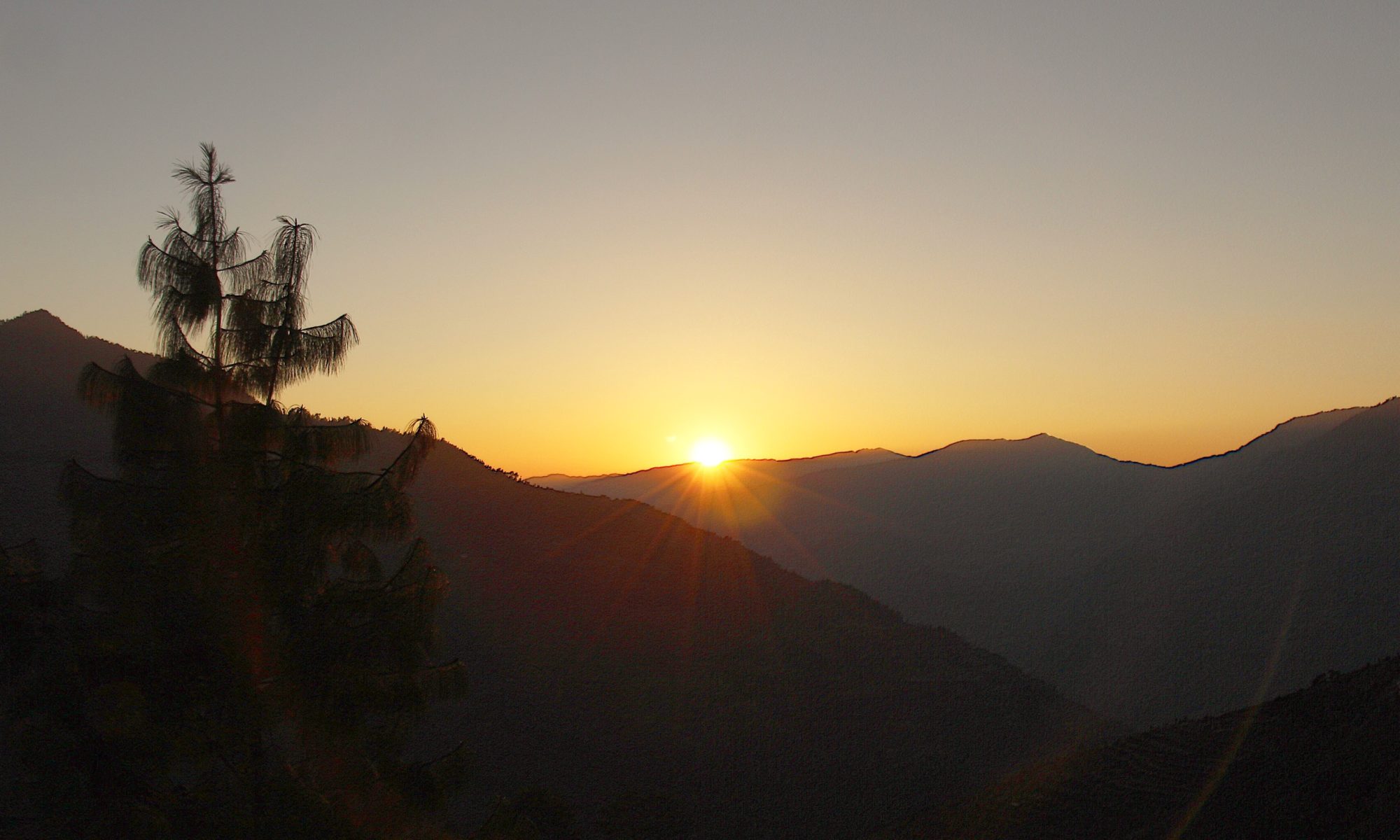
Before long flatter ground returns and soon I am standing on the rocky promontory that is the summit of Eagle Crag. Borrowdale lies to the north and the U shaped, ice carved curves of the Langstrath valley stretch south, Langstrath Beck meandering lazily along the valley floor. The eastern slope of Langstrath rises steeply up to form the ridge, along which is my second hill of the day, Sergeant’s Crag.

It’s a pleasant walk over to Sergeant’s Crag along the ridge. At first the path drops off Eagle Crag, crosses a wall and then slowly rises through heather and boggy ground to reach what is another rocky outcrop of a top.


The views are pretty much the same as Eagle Crag, not surprising as there is barely a mile between them but the aspect of each hill of course can be seen from the other. This reminds me of a conversation I had with someone in Paris who insisted there was absolutely no point going up the Eiffel Tower as you couldn’t see the best landmark in Paris, the Eiffel Tower from it. I ignored the strange logic and can confirm that the view of Paris from the top of the Eiffel Tower is magnifique, even if you can’t see what you are on top of.

Leaving Sergeant’s Crag I head towards the distinctive feature of Long Crag and then curve around the head of Greenup Valley to Greenup Edge. At Greenup Edge it’s time to take stock. I had given myself the option, if feeling good and time and weather were on my side of doing a ‘there and back’ to the summit of Ullscarf.

The weather so far today has been good but there are some low clouds starting to scrape the higher tops to the south. Surely I’ll be able to reach the summit of Ullscarf before they reach me? Options considered off I trot, at a pace slightly quicker than my norm to Ullscarf.

One of hillwalking’s unwritten rules is that the top is always further away than you would wish it to be. And so it came to pass that as I puffed my way, non stop, full gas to the top of Ullscarf, the top miraculously moved further away and the clouds, like King Canute’s tide came rolling in and there was nothing on Gods Green Earth I could do to stop them. I kept going, for the exercise if nothing else but by the time I stood at the cairn, the view, although not as bad as it could have been was most definitely not an acceptable one with the heights of Lakeland obscured by cloud.

Trudging back down, the clouds teased me by appearing to clear but then scudding back in, thicker than before. By the time I had dropped a hundred feet I was in clear air again and by Greenup Edge I was well below the clouds and all was bright.

Greenup Edge in the sunshine is benign and beautiful, in bad weather, the multitude of paths, valleys and flattish terrain make it a confusing and difficult place to find your way around. I once got completely and utterly lost on Greenup Edge dropping into Langdale instead of Far Easedale which is kind of like ending up in Blackpool when you were heading to Brighton.
*********************
This was long before the Americans let us use their satellites and gave us all access to that wonderful invention, the Global Positioning System, the blue dot telling us exactly where we are on this planet. In those far off days we had to rely upon map and compass, pace and timing. Which is all very well until you can’t see your hand in front of your face, are being blown off your feet and lose where you are on the map because the wind is trying to rip it out of your hands and torrential rain is slowly turning it into paper mache. That day was a day of driving rain, howling gales and the thickest murk I have walked in. My walking buddy was not best pleased to be in Langdale and the walk to Grasmere, our intended destination was a long and silent one. We got lost, but it could have been worse.
Note: This was long before those paving stones were laid, which I suspect would help greatly in mist


I stop at the impressive Lining Crag, where the path appears to lead straight over the edge of the precipice and admire the view down Greenup before tackling the actual path, which although steep and rocky doesn’t require wings and heads down the right hand side of the cliff face.

I walk down the valley to the sound of roaring waterfalls in Greenup Gill and the sight of Eagle Crag, which is once again rising up far above me.
To Find All My Walks In The Central Fells Click Here

Route Map, Walk Stats, Geolocated Pictures and 3D Flyover Video Below.
Click ‘Learn more’ on the map. Note: you won’t see this if reading in WordPress reader but click on the little world at the top of the page to view it on the browser.
Don’t like the look of that exposed zig zag path but I love the flagstones. Myself and my husband got a bit lost in the fog many years ago climbing Cader Idris – it lifted quite quickly though so we made it to the top.
Thanks Tricia, yes there are more flagstones appearing along the flatter paths I’ve noticed
Without any commentary and only the pictures, you could just tell right away that you were in the Lake District. Another great write-up Jim!
Thanks Dave, yes Lakeland does have its own unique identity, like no where else in the country
Was thinking how absolutely idyllic that looked, until the zigzag path on the fellside, but I reckon even I could do that (whilst assuming I was about to die, obviously). Lovely write up. I’ve missed your lakeland adventures.
Pictures always make things look worse than they are! And I’m sure you could do it. We disappear abroad for a big chunk of July, hence the gap. Looking forward to some nice autumn days, my favourite time of year
You’ve taken me on another couple of gorgeous walks. I do hate those deceptive summits though that keep moving further away 😊 Maggie
😂 Thanks Maggie, yes some days on the hill are easier than others😀
Another epic hike Jim! Though that cliffside path does look dicey..
Thanks Shazza, yes a little tricky but not for long thankfully 😀 P.S my spellcheck keeps changing you to Shazam so one day I’m going to miss it and call you that!
I don’t mind. 🤣
Looks like a great walk, however I am not sure about the zig zag path. Looks very close to the edge.
Thanks Mél, the pictures I think make it look worse and it doesn’t last long 😀
I’m with Melodie in regard to that zig zag walk. Apart from that the walk looks amazingly beautiful.
Thank you Suzanne, yes when the weathers good Lakeland is beautiful 😀
I really should look at doing Eagle Crag again, when I did it I made a huge error, walking to a great viewpoint described by Wainwright and forgetting to return to the rowan tree to find the zigzag route up. I ended up in waist high heather stuck on cliff faces, lucky not to get cragfast. Such a good walk this one and glad you headed to Ullscarf as it isn’t too far away (those slabs are definitely new as they weren’t there a couple of years ago when I did it
Thanks, sounds like you climbed up the crag itself! I’ll have to revisit Ullscarf but have a route on the other side I’ll try. The flagstones looked fairly new 😀
One of the two of us might find the zigzag a tad tricky with a fear of heights! 😩
The key is not to look down!
The scenery is just wonderful, Jim, but I think I’d have trembly knees doing that zigzag too. What if I panic and freeze to the spot? Awful how your confidence goes as you get older. My trusty other half got me through a tricky bit this last weekend.
Thanks Jo, that’s what other half’s are for 😀😍
🤗💙
Good report. I didn’t fancy that route up because of the exposure, so just bashed up the side between the two summits.
Thanks Tessa, yes there are a couple of airy bits!
Hi Jim
I am a solo walker ideally wanting to tick these three off in one day, I use OS on my phone for planning and following do you think I will manage it? Have heard and read not so great things about eagle and ulscarf one being very boggy and dangerous in places?
Hi Joanne, if you feel you are fit enough I don’t see why you shouldn’t be able to have a good day doing these. There is a little exposure on Eagle Crag, I’ve put some pictures on, only you will know if you can cope with that but compared to say, striding edge it’s nothing. Ullscarf is no boggier than many other quagmires, if you do it in the summer rather than winter. If you view the post in the browser/on the website you can see my route which you are welcome to use.